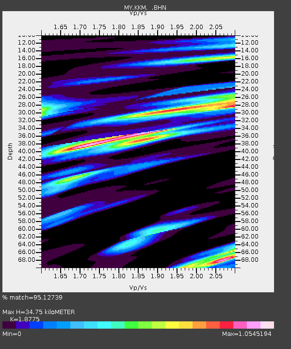
KKM Kota Kinabalu - Earthquake Result Viewer

Earthquake location: Vanuatu Islands
Earthquake latitude/longitude: -13.0/166.5
Earthquake time(UTC): 2009/10/07 (280) 22:03:14 GMT
Earthquake Depth: 45 km
Earthquake Magnitude: 6.4 MB, 7.3 MS, 7.6 MW, 7.7 MW
Earthquake Catalog/Contributor: WHDF/NEIC
Network: MY Malaysian National Seismic Network
Station: KKM Kota Kinabalu
Lat/Lon: 6.04 N/116.21 E
Elevation: 830 m
Distance: 53.4 deg
Az: 287.689 deg
Baz: 110.979 deg
Ray Param: 0.066000566
Estimated Moho Depth: 34.75 km
Estimated Crust Vp/Vs: 1.88
Assumed Crust Vp: 6.048 km/s
Estimated Crust Vs: 3.221 km/s
Estimated Crust Poisson's Ratio: 0.30
Radial Match: 95.12739 %
Radial Bump: 400
Transverse Match: 93.46154 %
Transverse Bump: 400
SOD ConfigId: 2622
Insert Time: 2010-03-09 03:24:06.474 +0000
GWidth: 2.5
Max Bumps: 400
Tol: 0.001

Signal To Noise

ChannelStoNSTALTA
MY:KKM: :BHN:20091007T22:11:59.220Z6.92746733.1025525E-64.4786245E-7
MY:KKM: :BHE:20091007T22:11:59.220Z1.06823059.837004E-79.2086896E-7
MY:KKM: :BHZ:20091007T22:11:59.220Z2.92218231.6806565E-65.7513745E-7
Arrivals
Ps5.3 SECOND
PpPs16 SECOND
PsPs/PpSs21 SECOND