You are here: Home > Network List > US - United States National Seismic Network Stations List
> Station CBKS Cedar Bluff, Kansas, USA > Earthquake Result Viewer
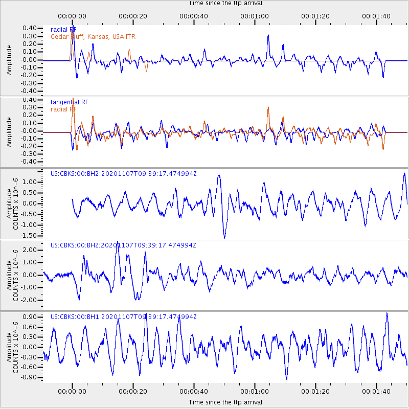
CBKS Cedar Bluff, Kansas, USA - Earthquake Result Viewer
*The percent match for this event was below the threshold and hence no stack was calculated.
| Earthquake location: |
Tonga Islands |
| Earthquake latitude/longitude: |
-15.3/-173.6 |
| Earthquake time(UTC): |
2020/11/07 (312) 09:27:04 GMT |
| Earthquake Depth: |
29 km |
| Earthquake Magnitude: |
6.1 Mww |
| Earthquake Catalog/Contributor: |
NEIC PDE/us |
|
| Network: |
US United States National Seismic Network |
| Station: |
CBKS Cedar Bluff, Kansas, USA |
| Lat/Lon: |
38.81 N/99.74 W |
| Elevation: |
677 m |
|
| Distance: |
87.3 deg |
| Az: |
48.688 deg |
| Baz: |
248.113 deg |
| Ray Param: |
$rayparam |
*The percent match for this event was below the threshold and hence was not used in the summary stack. |
|
| Radial Match: |
73.60583 % |
| Radial Bump: |
358 |
| Transverse Match: |
74.02894 % |
| Transverse Bump: |
400 |
| SOD ConfigId: |
23341671 |
| Insert Time: |
2020-11-21 10:56:11.158 +0000 |
| GWidth: |
2.5 |
| Max Bumps: |
400 |
| Tol: |
0.001 |
|
Signal To Noise
| Channel | StoN | STA | LTA |
| US:CBKS:00:BHZ:20201107T09:39:17.474994Z | 4.5910873 | 9.2190163E-7 | 2.0080246E-7 |
| US:CBKS:00:BH1:20201107T09:39:17.474994Z | 1.6550151 | 3.8898423E-7 | 2.3503364E-7 |
| US:CBKS:00:BH2:20201107T09:39:17.474994Z | 1.3940392 | 3.7221935E-7 | 2.670078E-7 |
| Arrivals |
| Ps | |
| PpPs | |
| PsPs/PpSs | |


