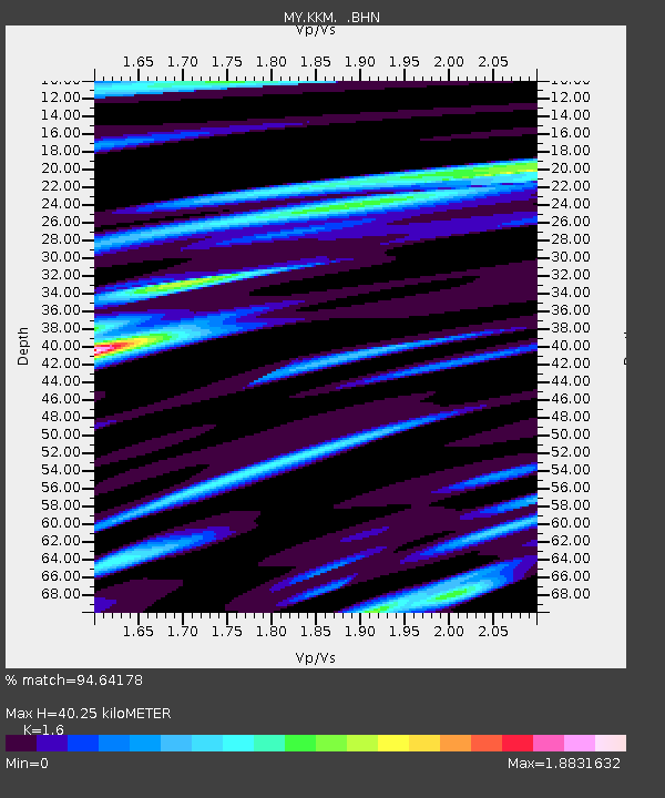
KKM Kota Kinabalu - Earthquake Result Viewer

Earthquake location: Off East Coast Of Honshu, Japan
Earthquake latitude/longitude: 36.5/142.4
Earthquake time(UTC): 2008/12/20 (355) 10:29:23 GMT
Earthquake Depth: 19 km
Earthquake Magnitude: 6.0 MB, 6.3 MS, 6.3 MW, 6.3 MW
Earthquake Catalog/Contributor: WHDF/NEIC
Network: MY Malaysian National Seismic Network
Station: KKM Kota Kinabalu
Lat/Lon: 6.04 N/116.21 E
Elevation: 830 m
Distance: 38.7 deg
Az: 224.646 deg
Baz: 34.684 deg
Ray Param: 0.07539547
Estimated Moho Depth: 40.25 km
Estimated Crust Vp/Vs: 1.60
Assumed Crust Vp: 6.048 km/s
Estimated Crust Vs: 3.78 km/s
Estimated Crust Poisson's Ratio: 0.18
Radial Match: 94.64178 %
Radial Bump: 400
Transverse Match: 87.10389 %
Transverse Bump: 400
SOD ConfigId: 2658
Insert Time: 2010-03-09 03:24:28.129 +0000
GWidth: 2.5
Max Bumps: 400
Tol: 0.001

Signal To Noise

ChannelStoNSTALTA
MY:KKM: :BHN:20081220T10:36:14.869012Z4.9073357.722192E-71.573602E-7
MY:KKM: :BHE:20081220T10:36:14.869012Z2.49943074.5241637E-71.8100776E-7
MY:KKM: :BHZ:20081220T10:36:14.869012Z2.3284644.6218307E-71.9849267E-7
Arrivals
Ps4.3 SECOND
PpPs16 SECOND
PsPs/PpSs20 SECOND