You are here: Home > Network List > US - United States National Seismic Network Stations List
> Station WUAZ Wupatki, Arizona, USA > Earthquake Result Viewer
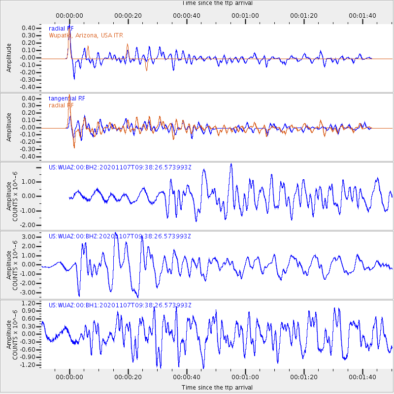
WUAZ Wupatki, Arizona, USA - Earthquake Result Viewer
*The percent match for this event was below the threshold and hence no stack was calculated.
| Earthquake location: |
Tonga Islands |
| Earthquake latitude/longitude: |
-15.3/-173.6 |
| Earthquake time(UTC): |
2020/11/07 (312) 09:27:04 GMT |
| Earthquake Depth: |
29 km |
| Earthquake Magnitude: |
6.1 Mww |
| Earthquake Catalog/Contributor: |
NEIC PDE/us |
|
| Network: |
US United States National Seismic Network |
| Station: |
WUAZ Wupatki, Arizona, USA |
| Lat/Lon: |
35.52 N/111.37 W |
| Elevation: |
1592 m |
|
| Distance: |
77.5 deg |
| Az: |
47.644 deg |
| Baz: |
240.957 deg |
| Ray Param: |
$rayparam |
*The percent match for this event was below the threshold and hence was not used in the summary stack. |
|
| Radial Match: |
79.911514 % |
| Radial Bump: |
400 |
| Transverse Match: |
80.48843 % |
| Transverse Bump: |
400 |
| SOD ConfigId: |
23341671 |
| Insert Time: |
2020-11-21 10:56:53.294 +0000 |
| GWidth: |
2.5 |
| Max Bumps: |
400 |
| Tol: |
0.001 |
|
Signal To Noise
| Channel | StoN | STA | LTA |
| US:WUAZ:00:BHZ:20201107T09:38:26.573993Z | 6.8608584 | 1.3649917E-6 | 1.9895349E-7 |
| US:WUAZ:00:BH1:20201107T09:38:26.573993Z | 0.82529247 | 2.0414952E-7 | 2.4736627E-7 |
| US:WUAZ:00:BH2:20201107T09:38:26.573993Z | 2.5934763 | 6.3271915E-7 | 2.4396564E-7 |
| Arrivals |
| Ps | |
| PpPs | |
| PsPs/PpSs | |


