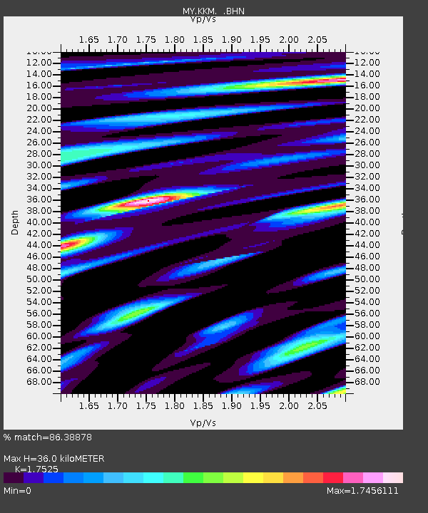
KKM Kota Kinabalu - Earthquake Result Viewer

Earthquake location: New Britain Region, P.N.G.
Earthquake latitude/longitude: -6.5/151.2
Earthquake time(UTC): 2006/11/07 (311) 17:38:33 GMT
Earthquake Depth: 10 km
Earthquake Magnitude: 6.2 MB, 6.3 MS, 6.5 MW, 6.4 MW
Earthquake Catalog/Contributor: WHDF/NEIC
Network: MY Malaysian National Seismic Network
Station: KKM Kota Kinabalu
Lat/Lon: 6.04 N/116.21 E
Elevation: 830 m
Distance: 37.1 deg
Az: 288.91 deg
Baz: 109.048 deg
Ray Param: 0.07634071
Estimated Moho Depth: 36.0 km
Estimated Crust Vp/Vs: 1.75
Assumed Crust Vp: 6.048 km/s
Estimated Crust Vs: 3.451 km/s
Estimated Crust Poisson's Ratio: 0.26
Radial Match: 86.38878 %
Radial Bump: 400
Transverse Match: 82.09608 %
Transverse Bump: 400
SOD ConfigId: 2564
Insert Time: 2010-03-09 03:24:39.597 +0000
GWidth: 2.5
Max Bumps: 400
Tol: 0.001

Signal To Noise

ChannelStoNSTALTA
MY:KKM: :BHN:20061107T17:45:12.968013Z1.21288441.6271095E-71.3415206E-7
MY:KKM: :BHE:20061107T17:45:12.968013Z1.46424341.7073414E-71.16602294E-7
MY:KKM: :BHZ:20061107T17:45:12.968013Z2.0850322.5317607E-71.214255E-7
Arrivals
Ps4.8 SECOND
PpPs15 SECOND
PsPs/PpSs20 SECOND