You are here: Home > Network List > XC94 - Puget Sound BB Array Stations List
> Station SEAL Seal Rock Campground > Earthquake Result Viewer
SEAL Seal Rock Campground - Earthquake Result Viewer
| Earthquake location: |
Fiji Islands Region |
| Earthquake latitude/longitude: |
-17.8/-178.5 |
| Earthquake time(UTC): |
1994/03/09 (068) 23:28:07 GMT |
| Earthquake Depth: |
564 km |
| Earthquake Magnitude: |
6.6 MB, 7.6 UNKNOWN, 7.6 MW |
| Earthquake Catalog/Contributor: |
WHDF/NEIC |
|
| Network: |
XC Puget Sound BB Array |
| Station: |
SEAL Seal Rock Campground |
| Lat/Lon: |
47.71 N/122.89 W |
| Elevation: |
24 m |
|
| Distance: |
82.0 deg |
| Az: |
34.255 deg |
| Baz: |
232.58 deg |
| Ray Param: |
0.04554109 |
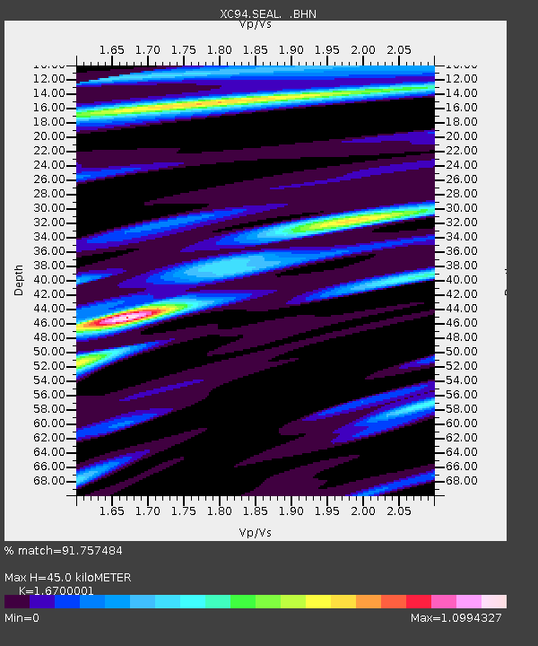
| Estimated Moho Depth: |
45.0 km |
| Estimated Crust Vp/Vs: |
1.67 |
| Assumed Crust Vp: |
6.566 km/s |
| Estimated Crust Vs: |
3.932 km/s |
| Estimated Crust Poisson's Ratio: |
0.22 |
|
| Radial Match: |
91.757484 % |
| Radial Bump: |
354 |
| Transverse Match: |
92.17682 % |
| Transverse Bump: |
393 |
| SOD ConfigId: |
16938 |
| Insert Time: |
2010-02-26 15:11:18.994 +0000 |
| GWidth: |
2.5 |
| Max Bumps: |
400 |
| Tol: |
0.001 |
|

Signal To Noise
| Channel | StoN | STA | LTA |
| XC:SEAL: :BHN:19940309T23:38:57.780017Z | 11.972185 | 2.7257524E-6 | 2.2767377E-7 |
| XC:SEAL: :BHE:19940309T23:38:57.780017Z | 8.89236 | 1.7723503E-6 | 1.9931159E-7 |
| XC:SEAL: :BHZ:19940309T23:38:57.780017Z | 77.22397 | 1.07053265E-5 | 1.3862699E-7 |
| Arrivals |
| Ps | 4.7 SECOND |
| PpPs | 18 SECOND |
| PsPs/PpSs | 23 SECOND |


