You are here: Home > Network List > TA - USArray Transportable Network (new EarthScope stations) Stations List
> Station H31M Peel River, Yukon, CAN > Earthquake Result Viewer
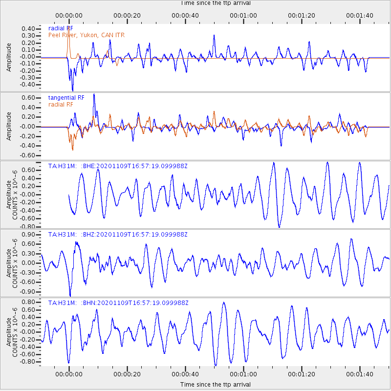
H31M Peel River, Yukon, CAN - Earthquake Result Viewer
*The percent match for this event was below the threshold and hence no stack was calculated.
| Earthquake location: |
New Ireland Region, P.N.G. |
| Earthquake latitude/longitude: |
-3.8/153.3 |
| Earthquake time(UTC): |
2020/11/09 (314) 16:45:33 GMT |
| Earthquake Depth: |
215 km |
| Earthquake Magnitude: |
5.5 Mww |
| Earthquake Catalog/Contributor: |
NEIC PDE/us |
|
| Network: |
TA USArray Transportable Network (new EarthScope stations) |
| Station: |
H31M Peel River, Yukon, CAN |
| Lat/Lon: |
65.81 N/134.34 W |
| Elevation: |
642 m |
|
| Distance: |
86.3 deg |
| Az: |
23.172 deg |
| Baz: |
252.306 deg |
| Ray Param: |
$rayparam |
*The percent match for this event was below the threshold and hence was not used in the summary stack. |
|
| Radial Match: |
41.732082 % |
| Radial Bump: |
400 |
| Transverse Match: |
74.290955 % |
| Transverse Bump: |
388 |
| SOD ConfigId: |
23341671 |
| Insert Time: |
2020-11-23 17:56:37.268 +0000 |
| GWidth: |
2.5 |
| Max Bumps: |
400 |
| Tol: |
0.001 |
|
Signal To Noise
| Channel | StoN | STA | LTA |
| TA:H31M: :BHZ:20201109T16:57:19.099988Z | 2.6649327 | 5.13642E-7 | 1.9274108E-7 |
| TA:H31M: :BHN:20201109T16:57:19.099988Z | 1.4184371 | 4.3587053E-7 | 3.072893E-7 |
| TA:H31M: :BHE:20201109T16:57:19.099988Z | 0.71265936 | 2.1971199E-7 | 3.0829875E-7 |
| Arrivals |
| Ps | |
| PpPs | |
| PsPs/PpSs | |


