You are here: Home > Network List > AV - Alaska Volcano Observatory Stations List
> Station SPCR Ckakachatna River, Mount Spurr, Alaska > Earthquake Result Viewer
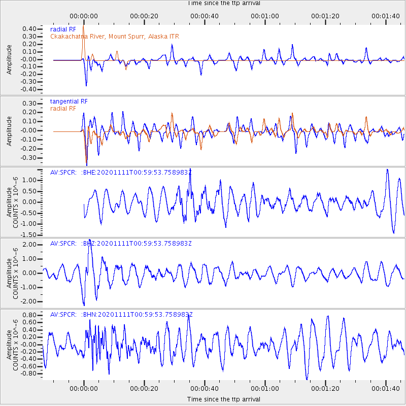
SPCR Ckakachatna River, Mount Spurr, Alaska - Earthquake Result Viewer
*The percent match for this event was below the threshold and hence no stack was calculated.
| Earthquake location: |
Fiji Islands Region |
| Earthquake latitude/longitude: |
-19.7/-177.6 |
| Earthquake time(UTC): |
2020/11/11 (316) 00:48:43 GMT |
| Earthquake Depth: |
417 km |
| Earthquake Magnitude: |
6.0 Mww |
| Earthquake Catalog/Contributor: |
NEIC PDE/us |
|
| Network: |
AV Alaska Volcano Observatory |
| Station: |
SPCR Ckakachatna River, Mount Spurr, Alaska |
| Lat/Lon: |
61.20 N/152.21 W |
| Elevation: |
984 m |
|
| Distance: |
83.2 deg |
| Az: |
12.048 deg |
| Baz: |
203.956 deg |
| Ray Param: |
$rayparam |
*The percent match for this event was below the threshold and hence was not used in the summary stack. |
|
| Radial Match: |
66.26758 % |
| Radial Bump: |
400 |
| Transverse Match: |
63.62687 % |
| Transverse Bump: |
400 |
| SOD ConfigId: |
23341671 |
| Insert Time: |
2020-11-25 01:54:40.895 +0000 |
| GWidth: |
2.5 |
| Max Bumps: |
400 |
| Tol: |
0.001 |
|
Signal To Noise
| Channel | StoN | STA | LTA |
| AV:SPCR: :BHZ:20201111T00:59:53.758983Z | 4.469135 | 1.4427411E-6 | 3.2282338E-7 |
| AV:SPCR: :BHN:20201111T00:59:53.758983Z | 1.0828408 | 3.332186E-7 | 3.0772628E-7 |
| AV:SPCR: :BHE:20201111T00:59:53.758983Z | 1.1425666 | 4.85579E-7 | 4.2498965E-7 |
| Arrivals |
| Ps | |
| PpPs | |
| PsPs/PpSs | |


