You are here: Home > Network List > IU - Global Seismograph Network (GSN - IRIS/USGS) Stations List
> Station PMG Port Moresby, New Guinea > Earthquake Result Viewer
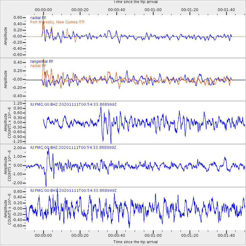
PMG Port Moresby, New Guinea - Earthquake Result Viewer
*The percent match for this event was below the threshold and hence no stack was calculated.
| Earthquake location: |
Fiji Islands Region |
| Earthquake latitude/longitude: |
-19.7/-177.6 |
| Earthquake time(UTC): |
2020/11/11 (316) 00:48:43 GMT |
| Earthquake Depth: |
417 km |
| Earthquake Magnitude: |
6.0 Mww |
| Earthquake Catalog/Contributor: |
NEIC PDE/us |
|
| Network: |
IU Global Seismograph Network (GSN - IRIS/USGS) |
| Station: |
PMG Port Moresby, New Guinea |
| Lat/Lon: |
9.40 S/147.16 E |
| Elevation: |
90 m |
|
| Distance: |
35.6 deg |
| Az: |
281.648 deg |
| Baz: |
110.78 deg |
| Ray Param: |
$rayparam |
*The percent match for this event was below the threshold and hence was not used in the summary stack. |
|
| Radial Match: |
68.17993 % |
| Radial Bump: |
400 |
| Transverse Match: |
66.59624 % |
| Transverse Bump: |
400 |
| SOD ConfigId: |
23341671 |
| Insert Time: |
2020-11-25 02:01:25.760 +0000 |
| GWidth: |
2.5 |
| Max Bumps: |
400 |
| Tol: |
0.001 |
|
Signal To Noise
| Channel | StoN | STA | LTA |
| IU:PMG:00:BHZ:20201111T00:54:33.868999Z | 6.9205766 | 1.0238115E-6 | 1.479373E-7 |
| IU:PMG:00:BH1:20201111T00:54:33.868999Z | 1.3748097 | 2.1211214E-7 | 1.5428473E-7 |
| IU:PMG:00:BH2:20201111T00:54:33.868999Z | 2.9936278 | 5.176127E-7 | 1.7290483E-7 |
| Arrivals |
| Ps | |
| PpPs | |
| PsPs/PpSs | |


