You are here: Home > Network List > TA - USArray Transportable Network (new EarthScope stations) Stations List
> Station I30M Mount Dempster, Yukon, CAN > Earthquake Result Viewer
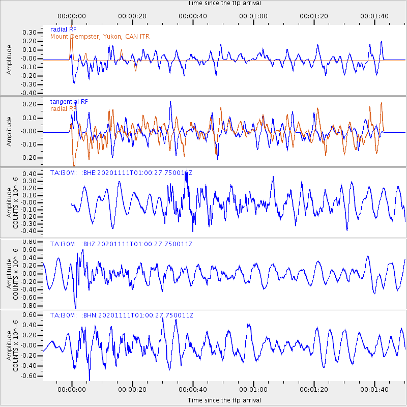
I30M Mount Dempster, Yukon, CAN - Earthquake Result Viewer
*The percent match for this event was below the threshold and hence no stack was calculated.
| Earthquake location: |
Fiji Islands Region |
| Earthquake latitude/longitude: |
-19.7/-177.6 |
| Earthquake time(UTC): |
2020/11/11 (316) 00:48:43 GMT |
| Earthquake Depth: |
417 km |
| Earthquake Magnitude: |
6.0 Mww |
| Earthquake Catalog/Contributor: |
NEIC PDE/us |
|
| Network: |
TA USArray Transportable Network (new EarthScope stations) |
| Station: |
I30M Mount Dempster, Yukon, CAN |
| Lat/Lon: |
65.22 N/136.38 W |
| Elevation: |
1399 m |
|
| Distance: |
90.3 deg |
| Az: |
16.108 deg |
| Baz: |
218.327 deg |
| Ray Param: |
$rayparam |
*The percent match for this event was below the threshold and hence was not used in the summary stack. |
|
| Radial Match: |
50.459297 % |
| Radial Bump: |
400 |
| Transverse Match: |
47.043667 % |
| Transverse Bump: |
373 |
| SOD ConfigId: |
23341671 |
| Insert Time: |
2020-11-25 02:07:06.612 +0000 |
| GWidth: |
2.5 |
| Max Bumps: |
400 |
| Tol: |
0.001 |
|
Signal To Noise
| Channel | StoN | STA | LTA |
| TA:I30M: :BHZ:20201111T01:00:27.750011Z | 3.021025 | 3.9149592E-7 | 1.2959042E-7 |
| TA:I30M: :BHN:20201111T01:00:27.750011Z | 1.9370748 | 2.4773422E-7 | 1.2789089E-7 |
| TA:I30M: :BHE:20201111T01:00:27.750011Z | 0.94753814 | 1.3894395E-7 | 1.466368E-7 |
| Arrivals |
| Ps | |
| PpPs | |
| PsPs/PpSs | |


