You are here: Home > Network List > US - United States National Seismic Network Stations List
> Station EGMT Eagleton, Montana, USA > Earthquake Result Viewer
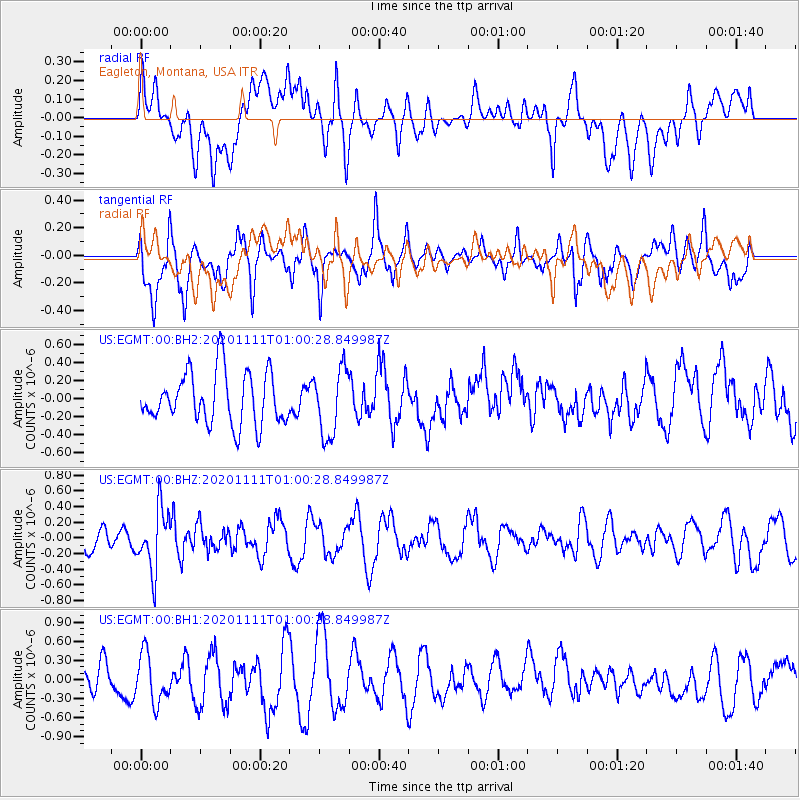
EGMT Eagleton, Montana, USA - Earthquake Result Viewer
*The percent match for this event was below the threshold and hence no stack was calculated.
| Earthquake location: |
Fiji Islands Region |
| Earthquake latitude/longitude: |
-19.7/-177.6 |
| Earthquake time(UTC): |
2020/11/11 (316) 00:48:43 GMT |
| Earthquake Depth: |
417 km |
| Earthquake Magnitude: |
6.0 Mww |
| Earthquake Catalog/Contributor: |
NEIC PDE/us |
|
| Network: |
US United States National Seismic Network |
| Station: |
EGMT Eagleton, Montana, USA |
| Lat/Lon: |
48.02 N/109.75 W |
| Elevation: |
1055 m |
|
| Distance: |
90.6 deg |
| Az: |
38.43 deg |
| Baz: |
240.709 deg |
| Ray Param: |
$rayparam |
*The percent match for this event was below the threshold and hence was not used in the summary stack. |
|
| Radial Match: |
44.455513 % |
| Radial Bump: |
400 |
| Transverse Match: |
59.735058 % |
| Transverse Bump: |
400 |
| SOD ConfigId: |
23341671 |
| Insert Time: |
2020-11-25 02:09:49.970 +0000 |
| GWidth: |
2.5 |
| Max Bumps: |
400 |
| Tol: |
0.001 |
|
Signal To Noise
| Channel | StoN | STA | LTA |
| US:EGMT:00:BHZ:20201111T01:00:28.849987Z | 2.5577474 | 3.9582585E-7 | 1.5475564E-7 |
| US:EGMT:00:BH1:20201111T01:00:28.849987Z | 1.4326 | 3.868196E-7 | 2.700123E-7 |
| US:EGMT:00:BH2:20201111T01:00:28.849987Z | 1.2863572 | 3.7131755E-7 | 2.886582E-7 |
| Arrivals |
| Ps | |
| PpPs | |
| PsPs/PpSs | |


