You are here: Home > Network List > CN - Canadian National Seismograph Network Stations List
> Station INK INUVIK, NT > Earthquake Result Viewer
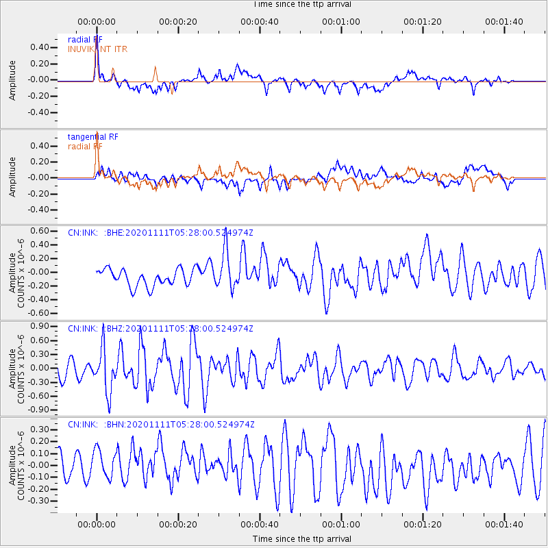
INK INUVIK, NT - Earthquake Result Viewer
*The percent match for this event was below the threshold and hence no stack was calculated.
| Earthquake location: |
Volcano Islands, Japan Region |
| Earthquake latitude/longitude: |
25.5/142.8 |
| Earthquake time(UTC): |
2020/11/11 (316) 05:17:56 GMT |
| Earthquake Depth: |
10 km |
| Earthquake Magnitude: |
5.7 Mww |
| Earthquake Catalog/Contributor: |
NEIC PDE/us |
|
| Network: |
CN Canadian National Seismograph Network |
| Station: |
INK INUVIK, NT |
| Lat/Lon: |
68.31 N/133.53 W |
| Elevation: |
44 m |
|
| Distance: |
64.3 deg |
| Az: |
24.214 deg |
| Baz: |
274.268 deg |
| Ray Param: |
$rayparam |
*The percent match for this event was below the threshold and hence was not used in the summary stack. |
|
| Radial Match: |
75.74384 % |
| Radial Bump: |
400 |
| Transverse Match: |
52.188763 % |
| Transverse Bump: |
400 |
| SOD ConfigId: |
23341671 |
| Insert Time: |
2020-11-25 06:26:40.445 +0000 |
| GWidth: |
2.5 |
| Max Bumps: |
400 |
| Tol: |
0.001 |
|
Signal To Noise
| Channel | StoN | STA | LTA |
| CN:INK: :BHZ:20201111T05:28:00.524974Z | 2.1234734 | 4.814465E-7 | 2.267259E-7 |
| CN:INK: :BHN:20201111T05:28:00.524974Z | 1.2407968 | 1.8691917E-7 | 1.5064445E-7 |
| CN:INK: :BHE:20201111T05:28:00.524974Z | 2.2873487 | 2.8266385E-7 | 1.2357705E-7 |
| Arrivals |
| Ps | |
| PpPs | |
| PsPs/PpSs | |


