You are here: Home > Network List > US - United States National Seismic Network Stations List
> Station DGMT Dagmar, Montana, USA > Earthquake Result Viewer
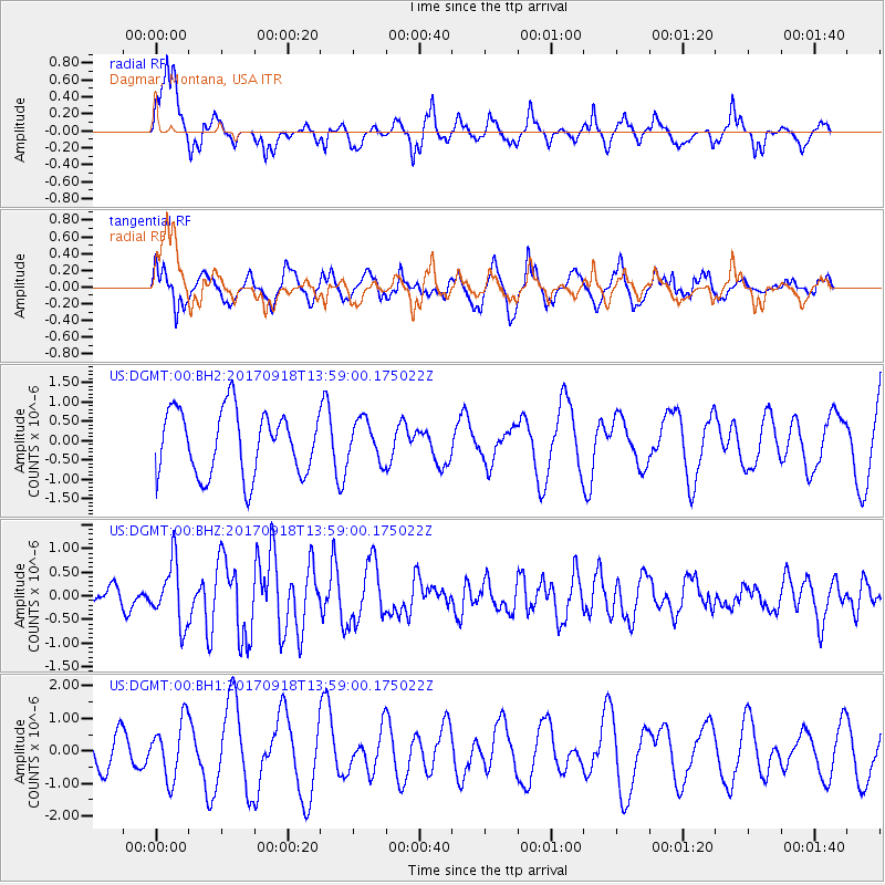
DGMT Dagmar, Montana, USA - Earthquake Result Viewer
*The percent match for this event was below the threshold and hence no stack was calculated.
| Earthquake location: |
Off Coast Of Central Chile |
| Earthquake latitude/longitude: |
-31.8/-72.1 |
| Earthquake time(UTC): |
2017/09/18 (261) 13:46:56 GMT |
| Earthquake Depth: |
10 km |
| Earthquake Magnitude: |
5.8 Mww |
| Earthquake Catalog/Contributor: |
NEIC PDE/us |
|
| Network: |
US United States National Seismic Network |
| Station: |
DGMT Dagmar, Montana, USA |
| Lat/Lon: |
48.47 N/104.20 W |
| Elevation: |
0.0 m |
|
| Distance: |
84.9 deg |
| Az: |
339.235 deg |
| Baz: |
153.031 deg |
| Ray Param: |
$rayparam |
*The percent match for this event was below the threshold and hence was not used in the summary stack. |
|
| Radial Match: |
72.97125 % |
| Radial Bump: |
375 |
| Transverse Match: |
63.553215 % |
| Transverse Bump: |
395 |
| SOD ConfigId: |
2341311 |
| Insert Time: |
2017-10-02 16:56:01.614 +0000 |
| GWidth: |
2.5 |
| Max Bumps: |
400 |
| Tol: |
0.001 |
|
Signal To Noise
| Channel | StoN | STA | LTA |
| US:DGMT:00:BHZ:20170918T13:59:00.175022Z | 2.4604049 | 6.386623E-7 | 2.595761E-7 |
| US:DGMT:00:BH1:20170918T13:59:00.175022Z | 1.2508425 | 8.816383E-7 | 7.048356E-7 |
| US:DGMT:00:BH2:20170918T13:59:00.175022Z | 0.6306648 | 5.244052E-7 | 8.3151167E-7 |
| Arrivals |
| Ps | |
| PpPs | |
| PsPs/PpSs | |


