You are here: Home > Network List > TA - USArray Transportable Network (new EarthScope stations) Stations List
> Station I30M Mount Dempster, Yukon, CAN > Earthquake Result Viewer
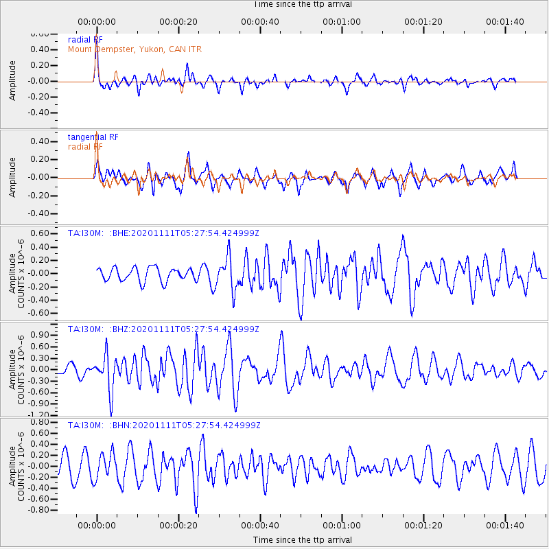
I30M Mount Dempster, Yukon, CAN - Earthquake Result Viewer
*The percent match for this event was below the threshold and hence no stack was calculated.
| Earthquake location: |
Volcano Islands, Japan Region |
| Earthquake latitude/longitude: |
25.5/142.8 |
| Earthquake time(UTC): |
2020/11/11 (316) 05:17:56 GMT |
| Earthquake Depth: |
10 km |
| Earthquake Magnitude: |
5.7 Mww |
| Earthquake Catalog/Contributor: |
NEIC PDE/us |
|
| Network: |
TA USArray Transportable Network (new EarthScope stations) |
| Station: |
I30M Mount Dempster, Yukon, CAN |
| Lat/Lon: |
65.22 N/136.38 W |
| Elevation: |
1399 m |
|
| Distance: |
63.4 deg |
| Az: |
27.739 deg |
| Baz: |
273.205 deg |
| Ray Param: |
$rayparam |
*The percent match for this event was below the threshold and hence was not used in the summary stack. |
|
| Radial Match: |
72.1881 % |
| Radial Bump: |
396 |
| Transverse Match: |
58.465984 % |
| Transverse Bump: |
400 |
| SOD ConfigId: |
23341671 |
| Insert Time: |
2020-11-25 06:35:49.691 +0000 |
| GWidth: |
2.5 |
| Max Bumps: |
400 |
| Tol: |
0.001 |
|
Signal To Noise
| Channel | StoN | STA | LTA |
| TA:I30M: :BHZ:20201111T05:27:54.424999Z | 5.0426645 | 4.796901E-7 | 9.512631E-8 |
| TA:I30M: :BHN:20201111T05:27:54.424999Z | 1.5341599 | 2.3150402E-7 | 1.5089954E-7 |
| TA:I30M: :BHE:20201111T05:27:54.424999Z | 2.4759443 | 2.494095E-7 | 1.0073309E-7 |
| Arrivals |
| Ps | |
| PpPs | |
| PsPs/PpSs | |


