You are here: Home > Network List > TA - USArray Transportable Network (new EarthScope stations) Stations List
> Station R31K City Hall, Gustavus, AK, USA > Earthquake Result Viewer
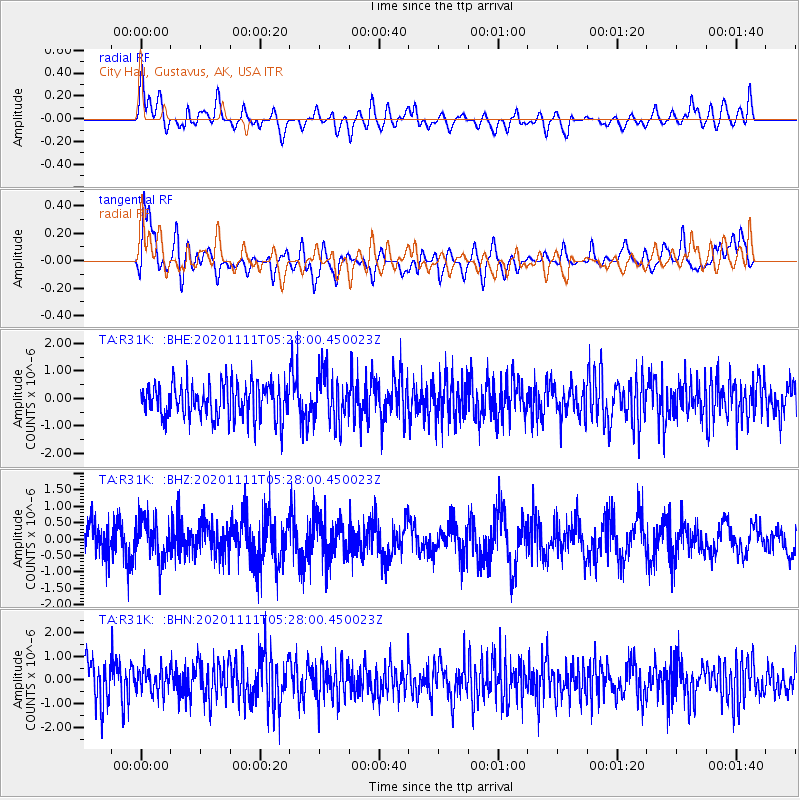
R31K City Hall, Gustavus, AK, USA - Earthquake Result Viewer
*The percent match for this event was below the threshold and hence no stack was calculated.
| Earthquake location: |
Volcano Islands, Japan Region |
| Earthquake latitude/longitude: |
25.5/142.8 |
| Earthquake time(UTC): |
2020/11/11 (316) 05:17:56 GMT |
| Earthquake Depth: |
10 km |
| Earthquake Magnitude: |
5.7 Mww |
| Earthquake Catalog/Contributor: |
NEIC PDE/us |
|
| Network: |
TA USArray Transportable Network (new EarthScope stations) |
| Station: |
R31K City Hall, Gustavus, AK, USA |
| Lat/Lon: |
58.41 N/135.74 W |
| Elevation: |
15 m |
|
| Distance: |
64.3 deg |
| Az: |
35.295 deg |
| Baz: |
277.103 deg |
| Ray Param: |
$rayparam |
*The percent match for this event was below the threshold and hence was not used in the summary stack. |
|
| Radial Match: |
47.564327 % |
| Radial Bump: |
400 |
| Transverse Match: |
64.6926 % |
| Transverse Bump: |
400 |
| SOD ConfigId: |
23341671 |
| Insert Time: |
2020-11-25 06:36:21.986 +0000 |
| GWidth: |
2.5 |
| Max Bumps: |
400 |
| Tol: |
0.001 |
|
Signal To Noise
| Channel | StoN | STA | LTA |
| TA:R31K: :BHZ:20201111T05:28:00.450023Z | 1.1521927 | 6.1570586E-7 | 5.343775E-7 |
| TA:R31K: :BHN:20201111T05:28:00.450023Z | 0.64120966 | 5.1780535E-7 | 8.075445E-7 |
| TA:R31K: :BHE:20201111T05:28:00.450023Z | 1.4008447 | 8.8288647E-7 | 6.3025294E-7 |
| Arrivals |
| Ps | |
| PpPs | |
| PsPs/PpSs | |


