You are here: Home > Network List > TA - USArray Transportable Network (new EarthScope stations) Stations List
> Station R33M Jennings River, BC, CAN > Earthquake Result Viewer
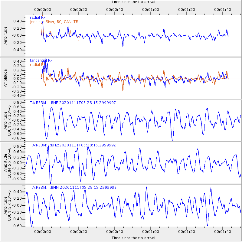
R33M Jennings River, BC, CAN - Earthquake Result Viewer
*The percent match for this event was below the threshold and hence no stack was calculated.
| Earthquake location: |
Volcano Islands, Japan Region |
| Earthquake latitude/longitude: |
25.5/142.8 |
| Earthquake time(UTC): |
2020/11/11 (316) 05:17:56 GMT |
| Earthquake Depth: |
10 km |
| Earthquake Magnitude: |
5.7 Mww |
| Earthquake Catalog/Contributor: |
NEIC PDE/us |
|
| Network: |
TA USArray Transportable Network (new EarthScope stations) |
| Station: |
R33M Jennings River, BC, CAN |
| Lat/Lon: |
59.39 N/130.97 W |
| Elevation: |
1437 m |
|
| Distance: |
66.6 deg |
| Az: |
33.808 deg |
| Baz: |
280.565 deg |
| Ray Param: |
$rayparam |
*The percent match for this event was below the threshold and hence was not used in the summary stack. |
|
| Radial Match: |
70.00686 % |
| Radial Bump: |
400 |
| Transverse Match: |
79.68202 % |
| Transverse Bump: |
400 |
| SOD ConfigId: |
23341671 |
| Insert Time: |
2020-11-25 06:36:22.283 +0000 |
| GWidth: |
2.5 |
| Max Bumps: |
400 |
| Tol: |
0.001 |
|
Signal To Noise
| Channel | StoN | STA | LTA |
| TA:R33M: :BHZ:20201111T05:28:15.299999Z | 1.8874717 | 5.517787E-7 | 2.923375E-7 |
| TA:R33M: :BHN:20201111T05:28:15.299999Z | 0.8118159 | 2.0022114E-7 | 2.4663368E-7 |
| TA:R33M: :BHE:20201111T05:28:15.299999Z | 0.897966 | 3.185835E-7 | 3.5478345E-7 |
| Arrivals |
| Ps | |
| PpPs | |
| PsPs/PpSs | |


