You are here: Home > Network List > MY - Malaysian National Seismic Network Stations List
> Station KOM Kota Tinggi > Earthquake Result Viewer
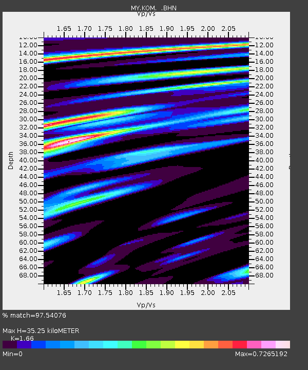
KOM Kota Tinggi - Earthquake Result Viewer
| Earthquake location: |
Eastern New Guinea Reg., P.N.G. |
| Earthquake latitude/longitude: |
-5.8/147.1 |
| Earthquake time(UTC): |
2007/11/22 (326) 08:48:27 GMT |
| Earthquake Depth: |
53 km |
| Earthquake Magnitude: |
6.0 MB, 6.7 MW, 6.7 MW |
| Earthquake Catalog/Contributor: |
WHDF/NEIC |
|
| Network: |
MY Malaysian National Seismic Network |
| Station: |
KOM Kota Tinggi |
| Lat/Lon: |
1.79 N/103.85 E |
| Elevation: |
49 m |
|
| Distance: |
43.8 deg |
| Az: |
278.59 deg |
| Baz: |
100.154 deg |
| Ray Param: |
0.07214268 |
| Estimated Moho Depth: |
35.25 km |
| Estimated Crust Vp/Vs: |
1.66 |
| Assumed Crust Vp: |
6.24 km/s |
| Estimated Crust Vs: |
3.759 km/s |
| Estimated Crust Poisson's Ratio: |
0.22 |
|
| Radial Match: |
97.54076 % |
| Radial Bump: |
330 |
| Transverse Match: |
84.588745 % |
| Transverse Bump: |
400 |
| SOD ConfigId: |
2564 |
| Insert Time: |
2010-03-09 03:28:38.065 +0000 |
| GWidth: |
2.5 |
| Max Bumps: |
400 |
| Tol: |
0.001 |
|

Signal To Noise
| Channel | StoN | STA | LTA |
| MY:KOM: :BHN:20071122T08:55:58.019014Z | 1.6530607 | 4.2748636E-7 | 2.5860294E-7 |
| MY:KOM: :BHE:20071122T08:55:58.019014Z | 3.940923 | 8.745642E-7 | 2.2191861E-7 |
| MY:KOM: :BHZ:20071122T08:55:58.019014Z | 8.131791 | 1.5247639E-6 | 1.8750652E-7 |
| Arrivals |
| Ps | 4.0 SECOND |
| PpPs | 14 SECOND |
| PsPs/PpSs | 18 SECOND |


