You are here: Home > Network List > IU - Global Seismograph Network (GSN - IRIS/USGS) Stations List
> Station PMG Port Moresby, New Guinea > Earthquake Result Viewer
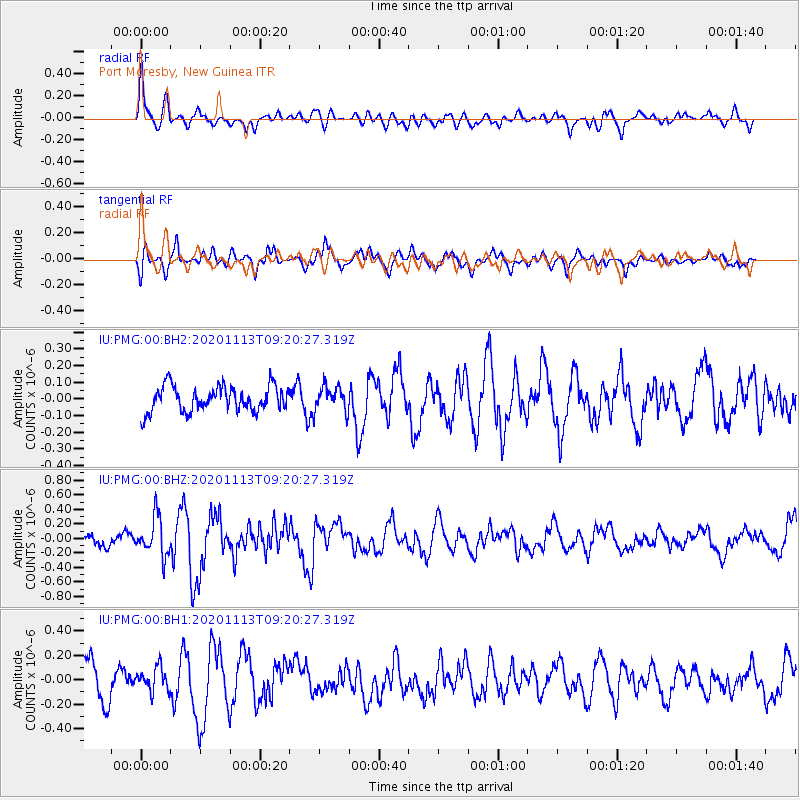
PMG Port Moresby, New Guinea - Earthquake Result Viewer
*The percent match for this event was below the threshold and hence no stack was calculated.
| Earthquake location: |
Macquarie Island Region |
| Earthquake latitude/longitude: |
-53.2/160.1 |
| Earthquake time(UTC): |
2020/11/13 (318) 09:12:43 GMT |
| Earthquake Depth: |
10 km |
| Earthquake Magnitude: |
5.7 Mww |
| Earthquake Catalog/Contributor: |
NEIC PDE/us |
|
| Network: |
IU Global Seismograph Network (GSN - IRIS/USGS) |
| Station: |
PMG Port Moresby, New Guinea |
| Lat/Lon: |
9.40 S/147.16 E |
| Elevation: |
90 m |
|
| Distance: |
44.9 deg |
| Az: |
341.815 deg |
| Baz: |
169.025 deg |
| Ray Param: |
$rayparam |
*The percent match for this event was below the threshold and hence was not used in the summary stack. |
|
| Radial Match: |
70.00182 % |
| Radial Bump: |
400 |
| Transverse Match: |
67.79991 % |
| Transverse Bump: |
400 |
| SOD ConfigId: |
23341671 |
| Insert Time: |
2020-11-27 10:15:34.062 +0000 |
| GWidth: |
2.5 |
| Max Bumps: |
400 |
| Tol: |
0.001 |
|
Signal To Noise
| Channel | StoN | STA | LTA |
| IU:PMG:00:BHZ:20201113T09:20:27.319Z | 3.0231698 | 2.661098E-7 | 8.8023434E-8 |
| IU:PMG:00:BH1:20201113T09:20:27.319Z | 0.8585388 | 9.821412E-8 | 1.1439683E-7 |
| IU:PMG:00:BH2:20201113T09:20:27.319Z | 0.9794134 | 7.40506E-8 | 7.560709E-8 |
| Arrivals |
| Ps | |
| PpPs | |
| PsPs/PpSs | |


