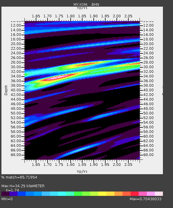
KOM Kota Tinggi - Earthquake Result Viewer

Earthquake location: Near West Coast Of Honshu, Japan
Earthquake latitude/longitude: 37.5/138.4
Earthquake time(UTC): 2007/07/16 (197) 01:13:22 GMT
Earthquake Depth: 12 km
Earthquake Magnitude: 6.5 MB, 6.4 MS, 6.6 MW, 6.5 MW
Earthquake Catalog/Contributor: WHDF/NEIC
Network: MY Malaysian National Seismic Network
Station: KOM Kota Tinggi
Lat/Lon: 1.79 N/103.85 E
Elevation: 49 m
Distance: 47.7 deg
Az: 230.107 deg
Baz: 37.605 deg
Ray Param: 0.06981189
Estimated Moho Depth: 34.25 km
Estimated Crust Vp/Vs: 1.74
Assumed Crust Vp: 6.24 km/s
Estimated Crust Vs: 3.586 km/s
Estimated Crust Poisson's Ratio: 0.25
Radial Match: 95.71954 %
Radial Bump: 353
Transverse Match: 73.3915 %
Transverse Bump: 400
SOD ConfigId: 2564
Insert Time: 2010-03-09 03:29:16.210 +0000
GWidth: 2.5
Max Bumps: 400
Tol: 0.001

Signal To Noise

ChannelStoNSTALTA
MY:KOM: :BHN:20070716T01:21:27.870Z3.33157061.116637E-63.3516835E-7
MY:KOM: :BHE:20070716T01:21:27.870Z3.47215847.886605E-72.271384E-7
MY:KOM: :BHZ:20070716T01:21:27.870Z17.4252282.3233872E-61.3333467E-7
Arrivals
Ps4.3 SECOND
PpPs14 SECOND
PsPs/PpSs18 SECOND