You are here: Home > Network List > CI - Caltech Regional Seismic Network Stations List
> Station MPM Manuel Prospect Mine, California, USA > Earthquake Result Viewer
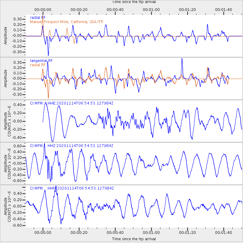
MPM Manuel Prospect Mine, California, USA - Earthquake Result Viewer
*The percent match for this event was below the threshold and hence no stack was calculated.
| Earthquake location: |
Vanuatu Islands |
| Earthquake latitude/longitude: |
-19.6/168.8 |
| Earthquake time(UTC): |
2020/11/14 (319) 06:42:34 GMT |
| Earthquake Depth: |
41 km |
| Earthquake Magnitude: |
5.5 Mww |
| Earthquake Catalog/Contributor: |
NEIC PDE/us |
|
| Network: |
CI Caltech Regional Seismic Network |
| Station: |
MPM Manuel Prospect Mine, California, USA |
| Lat/Lon: |
36.06 N/117.49 W |
| Elevation: |
185 m |
|
| Distance: |
88.9 deg |
| Az: |
51.084 deg |
| Baz: |
244.864 deg |
| Ray Param: |
$rayparam |
*The percent match for this event was below the threshold and hence was not used in the summary stack. |
|
| Radial Match: |
47.17423 % |
| Radial Bump: |
400 |
| Transverse Match: |
67.733574 % |
| Transverse Bump: |
400 |
| SOD ConfigId: |
23341671 |
| Insert Time: |
2020-11-28 07:49:17.437 +0000 |
| GWidth: |
2.5 |
| Max Bumps: |
400 |
| Tol: |
0.001 |
|
Signal To Noise
| Channel | StoN | STA | LTA |
| CI:MPM: :HHZ:20201114T06:54:53.127984Z | 1.9890989 | 3.4507988E-7 | 1.7348553E-7 |
| CI:MPM: :HHN:20201114T06:54:53.127984Z | 2.7663622 | 3.3085448E-7 | 1.1959911E-7 |
| CI:MPM: :HHE:20201114T06:54:53.127984Z | 0.4070026 | 9.6335235E-8 | 2.366944E-7 |
| Arrivals |
| Ps | |
| PpPs | |
| PsPs/PpSs | |


