You are here: Home > Network List > G - GEOSCOPE Stations List
> Station CLF Chambon la Foret observatory, France > Earthquake Result Viewer
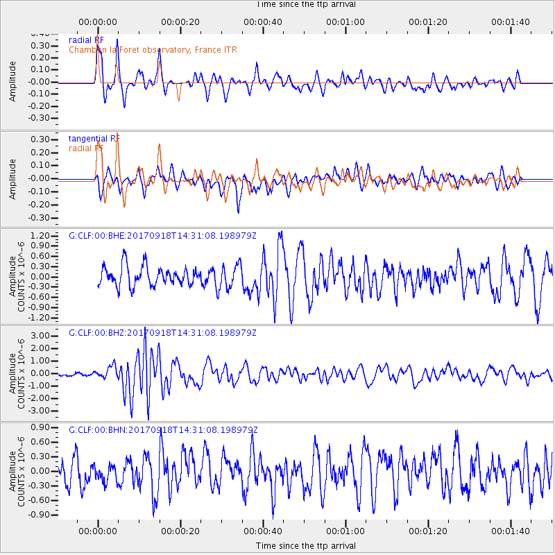
CLF Chambon la Foret observatory, France - Earthquake Result Viewer
*The percent match for this event was below the threshold and hence no stack was calculated.
| Earthquake location: |
Near Coast Of Oaxaca, Mexico |
| Earthquake latitude/longitude: |
15.3/-94.6 |
| Earthquake time(UTC): |
2017/09/18 (261) 14:19:12 GMT |
| Earthquake Depth: |
10 km |
| Earthquake Magnitude: |
5.6 Mww |
| Earthquake Catalog/Contributor: |
NEIC PDE/us |
|
| Network: |
G GEOSCOPE |
| Station: |
CLF Chambon la Foret observatory, France |
| Lat/Lon: |
48.03 N/2.26 E |
| Elevation: |
145 m |
|
| Distance: |
83.3 deg |
| Az: |
42.154 deg |
| Baz: |
285.203 deg |
| Ray Param: |
$rayparam |
*The percent match for this event was below the threshold and hence was not used in the summary stack. |
|
| Radial Match: |
74.77496 % |
| Radial Bump: |
400 |
| Transverse Match: |
60.565357 % |
| Transverse Bump: |
400 |
| SOD ConfigId: |
2341311 |
| Insert Time: |
2017-10-02 17:05:25.561 +0000 |
| GWidth: |
2.5 |
| Max Bumps: |
400 |
| Tol: |
0.001 |
|
Signal To Noise
| Channel | StoN | STA | LTA |
| G:CLF:00:BHZ:20170918T14:31:08.198979Z | 3.9033878 | 5.0008254E-7 | 1.2811499E-7 |
| G:CLF:00:BHN:20170918T14:31:08.198979Z | 0.6618219 | 1.8430818E-7 | 2.7848606E-7 |
| G:CLF:00:BHE:20170918T14:31:08.198979Z | 1.2977644 | 3.6131254E-7 | 2.784115E-7 |
| Arrivals |
| Ps | |
| PpPs | |
| PsPs/PpSs | |


