You are here: Home > Network List > MY - Malaysian National Seismic Network Stations List
> Station KOM Kota Tinggi > Earthquake Result Viewer
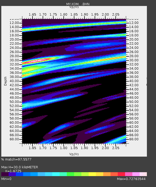
KOM Kota Tinggi - Earthquake Result Viewer
| Earthquake location: |
New Ireland Region, P.N.G. |
| Earthquake latitude/longitude: |
-5.2/153.7 |
| Earthquake time(UTC): |
2009/06/23 (174) 14:19:17 GMT |
| Earthquake Depth: |
65 km |
| Earthquake Magnitude: |
5.5 MB |
| Earthquake Catalog/Contributor: |
WHDF/NEIC |
|
| Network: |
MY Malaysian National Seismic Network |
| Station: |
KOM Kota Tinggi |
| Lat/Lon: |
1.79 N/103.85 E |
| Elevation: |
49 m |
|
| Distance: |
50.3 deg |
| Az: |
276.642 deg |
| Baz: |
98.218 deg |
| Ray Param: |
0.06797343 |
| Estimated Moho Depth: |
30.0 km |
| Estimated Crust Vp/Vs: |
1.67 |
| Assumed Crust Vp: |
6.24 km/s |
| Estimated Crust Vs: |
3.731 km/s |
| Estimated Crust Poisson's Ratio: |
0.22 |
|
| Radial Match: |
97.5577 % |
| Radial Bump: |
248 |
| Transverse Match: |
92.894646 % |
| Transverse Bump: |
400 |
| SOD ConfigId: |
2648 |
| Insert Time: |
2010-03-09 03:30:11.517 +0000 |
| GWidth: |
2.5 |
| Max Bumps: |
400 |
| Tol: |
0.001 |
|

Signal To Noise
| Channel | StoN | STA | LTA |
| MY:KOM: :BHN:20090623T14:27:37.06899Z | 4.173194 | 3.1526872E-7 | 7.554615E-8 |
| MY:KOM: :BHE:20090623T14:27:37.06899Z | 1.1290686 | 7.770351E-8 | 6.8820896E-8 |
| MY:KOM: :BHZ:20090623T14:27:37.06899Z | 2.4598622 | 1.5504422E-7 | 6.302963E-8 |
| Arrivals |
| Ps | 3.4 SECOND |
| PpPs | 12 SECOND |
| PsPs/PpSs | 16 SECOND |


