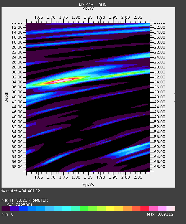
KOM Kota Tinggi - Earthquake Result Viewer

Earthquake location: East Of Kuril Islands
Earthquake latitude/longitude: 46.2/154.4
Earthquake time(UTC): 2006/12/07 (341) 19:10:21 GMT
Earthquake Depth: 16 km
Earthquake Magnitude: 6.3 MB, 6.1 MS, 6.3 MW, 6.3 MW
Earthquake Catalog/Contributor: WHDF/NEIC
Network: MY Malaysian National Seismic Network
Station: KOM Kota Tinggi
Lat/Lon: 1.79 N/103.85 E
Elevation: 49 m
Distance: 62.4 deg
Az: 240.587 deg
Baz: 37.289 deg
Ray Param: 0.060264744
Estimated Moho Depth: 33.25 km
Estimated Crust Vp/Vs: 1.74
Assumed Crust Vp: 6.24 km/s
Estimated Crust Vs: 3.581 km/s
Estimated Crust Poisson's Ratio: 0.25
Radial Match: 94.48122 %
Radial Bump: 381
Transverse Match: 71.53698 %
Transverse Bump: 400
SOD ConfigId: 2564
Insert Time: 2010-03-09 03:30:19.334 +0000
GWidth: 2.5
Max Bumps: 400
Tol: 0.001

Signal To Noise

ChannelStoNSTALTA
MY:KOM: :BHN:20061207T19:20:12.420007Z4.23437743.770937E-78.905529E-8
MY:KOM: :BHE:20061207T19:20:12.420007Z4.31209373.035107E-77.0385916E-8
MY:KOM: :BHZ:20061207T19:20:12.420007Z11.0400069.357995E-78.47644E-8
Arrivals
Ps4.1 SECOND
PpPs14 SECOND
PsPs/PpSs18 SECOND