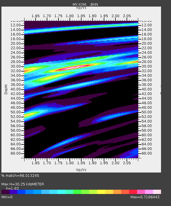
KOM Kota Tinggi - Earthquake Result Viewer

Earthquake location: New Britain Region, P.N.G.
Earthquake latitude/longitude: -6.4/151.2
Earthquake time(UTC): 2006/11/13 (317) 16:12:28 GMT
Earthquake Depth: 11 km
Earthquake Magnitude: 6.1 MB, 5.9 MS, 6.2 MW, 6.1 MW
Earthquake Catalog/Contributor: WHDF/NEIC
Network: MY Malaysian National Seismic Network
Station: KOM Kota Tinggi
Lat/Lon: 1.79 N/103.85 E
Elevation: 49 m
Distance: 48.0 deg
Az: 278.169 deg
Baz: 100.173 deg
Ray Param: 0.0696369
Estimated Moho Depth: 30.25 km
Estimated Crust Vp/Vs: 1.82
Assumed Crust Vp: 6.24 km/s
Estimated Crust Vs: 3.429 km/s
Estimated Crust Poisson's Ratio: 0.28
Radial Match: 96.013245 %
Radial Bump: 335
Transverse Match: 78.55487 %
Transverse Bump: 400
SOD ConfigId: 2564
Insert Time: 2010-03-09 03:30:28.042 +0000
GWidth: 2.5
Max Bumps: 400
Tol: 0.001

Signal To Noise

ChannelStoNSTALTA
MY:KOM: :BHN:20061113T16:20:36.870015Z1.42493511.706312E-71.1974664E-7
MY:KOM: :BHE:20061113T16:20:36.870015Z8.1328196.0162483E-77.397494E-8
MY:KOM: :BHZ:20061113T16:20:36.870015Z9.3526791.3154859E-61.4065338E-7
Arrivals
Ps4.2 SECOND
PpPs13 SECOND
PsPs/PpSs17 SECOND