You are here: Home > Network List > AK - Alaska Regional Network Stations List
> Station G19K Purcell Mountains, AK, USA > Earthquake Result Viewer
G19K Purcell Mountains, AK, USA - Earthquake Result Viewer
| Earthquake location: |
Mindanao, Philippines |
| Earthquake latitude/longitude: |
8.7/126.3 |
| Earthquake time(UTC): |
2020/11/15 (320) 22:37:45 GMT |
| Earthquake Depth: |
59 km |
| Earthquake Magnitude: |
5.9 mww |
| Earthquake Catalog/Contributor: |
NEIC PDE/us |
|
| Network: |
AK Alaska Regional Network |
| Station: |
G19K Purcell Mountains, AK, USA |
| Lat/Lon: |
66.14 N/157.09 W |
| Elevation: |
391 m |
|
| Distance: |
76.7 deg |
| Az: |
23.995 deg |
| Baz: |
261.273 deg |
| Ray Param: |
0.05072905 |
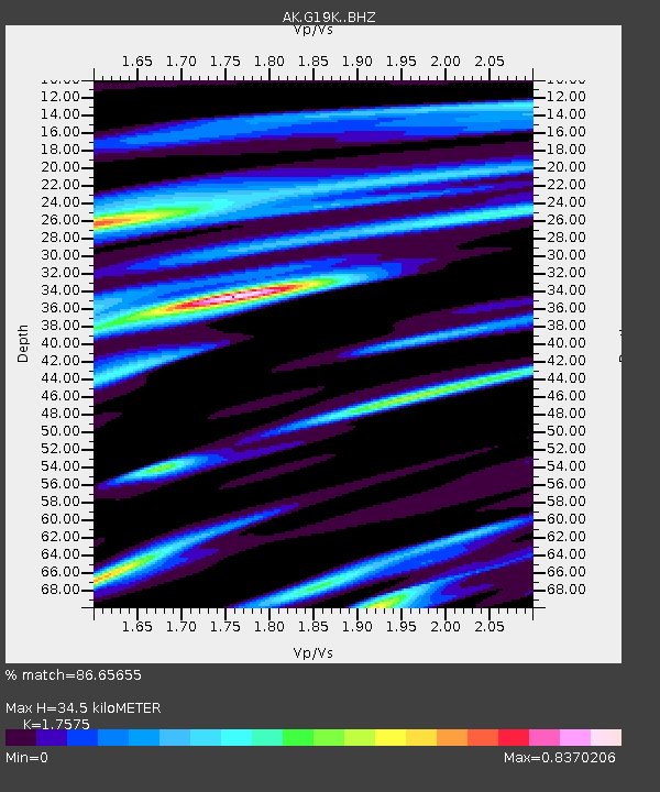
| Estimated Moho Depth: |
34.5 km |
| Estimated Crust Vp/Vs: |
1.76 |
| Assumed Crust Vp: |
6.577 km/s |
| Estimated Crust Vs: |
3.742 km/s |
| Estimated Crust Poisson's Ratio: |
0.26 |
|
| Radial Match: |
86.65655 % |
| Radial Bump: |
359 |
| Transverse Match: |
76.03928 % |
| Transverse Bump: |
400 |
| SOD ConfigId: |
23341671 |
| Insert Time: |
2020-11-29 23:42:37.982 +0000 |
| GWidth: |
2.5 |
| Max Bumps: |
400 |
| Tol: |
0.001 |
|

Signal To Noise
| Channel | StoN | STA | LTA |
| AK:G19K: :BHZ:20201115T22:48:59.059998Z | 7.822276 | 1.1254587E-6 | 1.4387867E-7 |
| AK:G19K: :BHN:20201115T22:48:59.059998Z | 1.6666873 | 2.1850852E-7 | 1.3110348E-7 |
| AK:G19K: :BHE:20201115T22:48:59.059998Z | 3.1560416 | 5.031885E-7 | 1.5943658E-7 |
| Arrivals |
| Ps | 4.1 SECOND |
| PpPs | 14 SECOND |
| PsPs/PpSs | 18 SECOND |


