You are here: Home > Network List > CN - Canadian National Seismograph Network Stations List
> Station INK INUVIK, NT > Earthquake Result Viewer
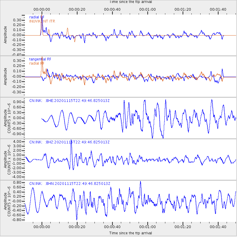
INK INUVIK, NT - Earthquake Result Viewer
*The percent match for this event was below the threshold and hence no stack was calculated.
| Earthquake location: |
Mindanao, Philippines |
| Earthquake latitude/longitude: |
8.7/126.3 |
| Earthquake time(UTC): |
2020/11/15 (320) 22:37:45 GMT |
| Earthquake Depth: |
59 km |
| Earthquake Magnitude: |
5.9 mww |
| Earthquake Catalog/Contributor: |
NEIC PDE/us |
|
| Network: |
CN Canadian National Seismograph Network |
| Station: |
INK INUVIK, NT |
| Lat/Lon: |
68.31 N/133.53 W |
| Elevation: |
44 m |
|
| Distance: |
85.7 deg |
| Az: |
21.528 deg |
| Baz: |
282.646 deg |
| Ray Param: |
$rayparam |
*The percent match for this event was below the threshold and hence was not used in the summary stack. |
|
| Radial Match: |
68.68415 % |
| Radial Bump: |
400 |
| Transverse Match: |
47.621693 % |
| Transverse Bump: |
400 |
| SOD ConfigId: |
23341671 |
| Insert Time: |
2020-11-29 23:46:01.026 +0000 |
| GWidth: |
2.5 |
| Max Bumps: |
400 |
| Tol: |
0.001 |
|
Signal To Noise
| Channel | StoN | STA | LTA |
| CN:INK: :BHZ:20201115T22:49:46.825013Z | 1.8933793 | 9.862347E-7 | 5.208859E-7 |
| CN:INK: :BHN:20201115T22:49:46.825013Z | 0.5442991 | 2.0452828E-7 | 3.757645E-7 |
| CN:INK: :BHE:20201115T22:49:46.825013Z | 1.3104503 | 3.275741E-7 | 2.4997064E-7 |
| Arrivals |
| Ps | |
| PpPs | |
| PsPs/PpSs | |


