You are here: Home > Network List > GT - Global Telemetered Seismograph Network (USAF/USGS) Stations List
> Station LPAZ La Paz , Bolivia > Earthquake Result Viewer
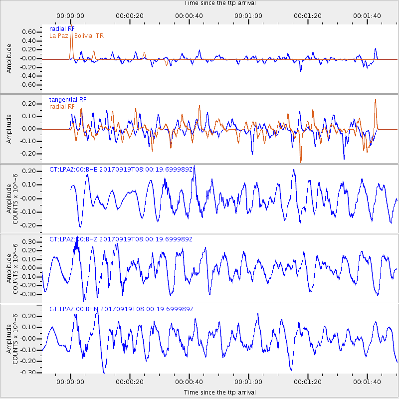
LPAZ La Paz , Bolivia - Earthquake Result Viewer
*The percent match for this event was below the threshold and hence no stack was calculated.
| Earthquake location: |
Near Coast Of Oaxaca, Mexico |
| Earthquake latitude/longitude: |
15.1/-94.1 |
| Earthquake time(UTC): |
2017/09/19 (262) 07:53:13 GMT |
| Earthquake Depth: |
16 km |
| Earthquake Magnitude: |
5.5 Mww |
| Earthquake Catalog/Contributor: |
NEIC PDE/us |
|
| Network: |
GT Global Telemetered Seismograph Network (USAF/USGS) |
| Station: |
LPAZ La Paz , Bolivia |
| Lat/Lon: |
16.17 S/68.08 W |
| Elevation: |
4817 m |
|
| Distance: |
40.3 deg |
| Az: |
139.407 deg |
| Baz: |
319.156 deg |
| Ray Param: |
$rayparam |
*The percent match for this event was below the threshold and hence was not used in the summary stack. |
|
| Radial Match: |
57.6973 % |
| Radial Bump: |
400 |
| Transverse Match: |
58.790703 % |
| Transverse Bump: |
400 |
| SOD ConfigId: |
2341311 |
| Insert Time: |
2017-10-03 10:05:55.923 +0000 |
| GWidth: |
2.5 |
| Max Bumps: |
400 |
| Tol: |
0.001 |
|
Signal To Noise
| Channel | StoN | STA | LTA |
| GT:LPAZ:00:BHZ:20170919T08:00:19.699989Z | 1.9194727 | 2.1075444E-7 | 1.09798094E-7 |
| GT:LPAZ:00:BHN:20170919T08:00:19.699989Z | 1.0405332 | 1.2425906E-7 | 1.1941864E-7 |
| GT:LPAZ:00:BHE:20170919T08:00:19.699989Z | 1.2398971 | 9.719061E-8 | 7.838602E-8 |
| Arrivals |
| Ps | |
| PpPs | |
| PsPs/PpSs | |


