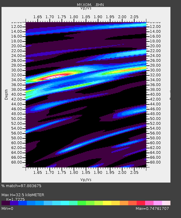
KOM Kota Tinggi - Earthquake Result Viewer

Earthquake location: Kuril Islands
Earthquake latitude/longitude: 46.0/151.4
Earthquake time(UTC): 2009/04/18 (108) 19:17:58 GMT
Earthquake Depth: 35 km
Earthquake Magnitude: 6.3 MB, 6.3 MS, 6.6 MW, 6.4 MW
Earthquake Catalog/Contributor: WHDF/NEIC
Network: MY Malaysian National Seismic Network
Station: KOM Kota Tinggi
Lat/Lon: 1.79 N/103.85 E
Elevation: 49 m
Distance: 60.5 deg
Az: 237.954 deg
Baz: 36.226 deg
Ray Param: 0.06141707
Estimated Moho Depth: 32.5 km
Estimated Crust Vp/Vs: 1.72
Assumed Crust Vp: 6.24 km/s
Estimated Crust Vs: 3.623 km/s
Estimated Crust Poisson's Ratio: 0.25
Radial Match: 97.883675 %
Radial Bump: 309
Transverse Match: 89.11522 %
Transverse Bump: 400
SOD ConfigId: 2760
Insert Time: 2010-03-09 03:31:09.451 +0000
GWidth: 2.5
Max Bumps: 400
Tol: 0.001

Signal To Noise

ChannelStoNSTALTA
MY:KOM: :BHN:20090418T19:27:34.820015Z16.5614451.2860876E-67.7655514E-8
MY:KOM: :BHE:20090418T19:27:34.820015Z7.4575175.19737E-76.969304E-8
MY:KOM: :BHZ:20090418T19:27:34.820015Z5.9702413.8461556E-76.442212E-8
Arrivals
Ps3.9 SECOND
PpPs14 SECOND
PsPs/PpSs17 SECOND