You are here: Home > Network List > MY - Malaysian National Seismic Network Stations List
> Station KOM Kota Tinggi > Earthquake Result Viewer
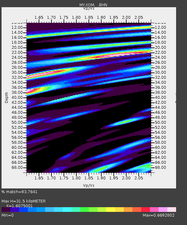
KOM Kota Tinggi - Earthquake Result Viewer
| Earthquake location: |
New Britain Region, P.N.G. |
| Earthquake latitude/longitude: |
-5.7/149.5 |
| Earthquake time(UTC): |
2009/05/12 (132) 01:26:26 GMT |
| Earthquake Depth: |
84 km |
| Earthquake Magnitude: |
5.9 MB, 6.1 MW, 6.1 MW |
| Earthquake Catalog/Contributor: |
WHDF/NEIC |
|
| Network: |
MY Malaysian National Seismic Network |
| Station: |
KOM Kota Tinggi |
| Lat/Lon: |
1.79 N/103.85 E |
| Elevation: |
49 m |
|
| Distance: |
46.2 deg |
| Az: |
277.899 deg |
| Baz: |
99.518 deg |
| Ray Param: |
0.070511036 |
| Estimated Moho Depth: |
31.5 km |
| Estimated Crust Vp/Vs: |
1.61 |
| Assumed Crust Vp: |
6.24 km/s |
| Estimated Crust Vs: |
3.882 km/s |
| Estimated Crust Poisson's Ratio: |
0.18 |
|
| Radial Match: |
93.7641 % |
| Radial Bump: |
340 |
| Transverse Match: |
77.253075 % |
| Transverse Bump: |
400 |
| SOD ConfigId: |
2760 |
| Insert Time: |
2010-03-09 03:31:13.027 +0000 |
| GWidth: |
2.5 |
| Max Bumps: |
400 |
| Tol: |
0.001 |
|

Signal To Noise
| Channel | StoN | STA | LTA |
| MY:KOM: :BHN:20090512T01:34:12.36899Z | 8.031123 | 6.41791E-7 | 7.991299E-8 |
| MY:KOM: :BHE:20090512T01:34:12.36899Z | 0.7380606 | 1.5952911E-7 | 2.1614635E-7 |
| MY:KOM: :BHZ:20090512T01:34:12.36899Z | 1.8416514 | 3.3740582E-7 | 1.832083E-7 |
| Arrivals |
| Ps | 3.3 SECOND |
| PpPs | 12 SECOND |
| PsPs/PpSs | 16 SECOND |


