You are here: Home > Network List > TA - USArray Transportable Network (new EarthScope stations) Stations List
> Station E23K Chandalar, AK, USA > Earthquake Result Viewer
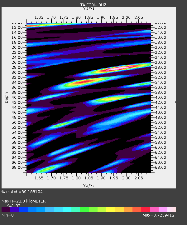
E23K Chandalar, AK, USA - Earthquake Result Viewer
| Earthquake location: |
Mindanao, Philippines |
| Earthquake latitude/longitude: |
8.7/126.3 |
| Earthquake time(UTC): |
2020/11/15 (320) 22:37:45 GMT |
| Earthquake Depth: |
59 km |
| Earthquake Magnitude: |
5.9 mww |
| Earthquake Catalog/Contributor: |
NEIC PDE/us |
|
| Network: |
TA USArray Transportable Network (new EarthScope stations) |
| Station: |
E23K Chandalar, AK, USA |
| Lat/Lon: |
68.06 N/149.62 W |
| Elevation: |
1084 m |
|
| Distance: |
79.8 deg |
| Az: |
22.327 deg |
| Baz: |
267.809 deg |
| Ray Param: |
0.048636485 |
| Estimated Moho Depth: |
28.0 km |
| Estimated Crust Vp/Vs: |
1.97 |
| Assumed Crust Vp: |
6.316 km/s |
| Estimated Crust Vs: |
3.206 km/s |
| Estimated Crust Poisson's Ratio: |
0.33 |
|
| Radial Match: |
89.185104 % |
| Radial Bump: |
400 |
| Transverse Match: |
74.531876 % |
| Transverse Bump: |
400 |
| SOD ConfigId: |
23341671 |
| Insert Time: |
2020-11-29 23:50:37.168 +0000 |
| GWidth: |
2.5 |
| Max Bumps: |
400 |
| Tol: |
0.001 |
|

Signal To Noise
| Channel | StoN | STA | LTA |
| TA:E23K: :BHZ:20201115T22:49:16.099976Z | 5.062858 | 9.583017E-7 | 1.8928078E-7 |
| TA:E23K: :BHN:20201115T22:49:16.099976Z | 0.610272 | 1.0828865E-7 | 1.7744325E-7 |
| TA:E23K: :BHE:20201115T22:49:16.099976Z | 3.5568862 | 2.4562752E-7 | 6.9056895E-8 |
| Arrivals |
| Ps | 4.4 SECOND |
| PpPs | 13 SECOND |
| PsPs/PpSs | 17 SECOND |


