You are here: Home > Network List > TA - USArray Transportable Network (new EarthScope stations) Stations List
> Station F19K Shaleruckik Mountain, AK, USA > Earthquake Result Viewer
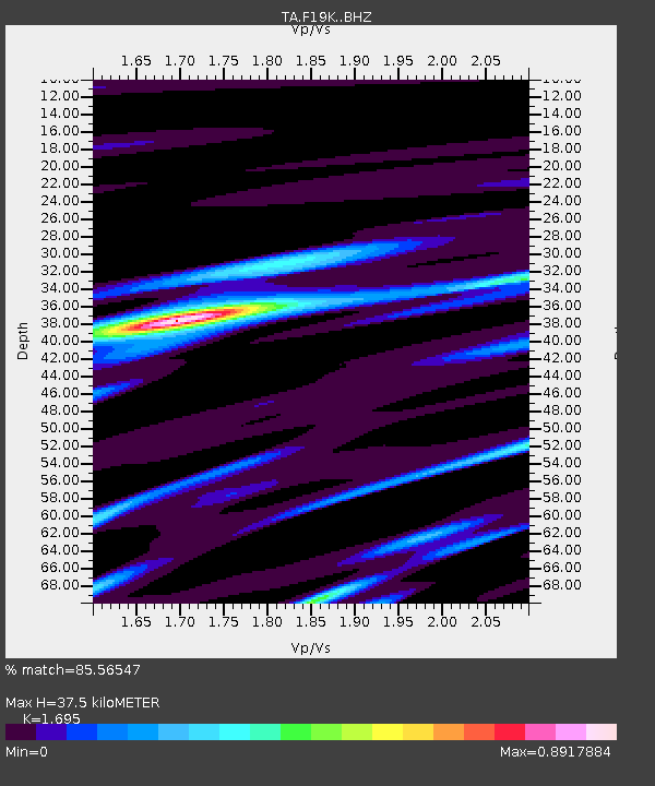
F19K Shaleruckik Mountain, AK, USA - Earthquake Result Viewer
| Earthquake location: |
Mindanao, Philippines |
| Earthquake latitude/longitude: |
8.7/126.3 |
| Earthquake time(UTC): |
2020/11/15 (320) 22:37:45 GMT |
| Earthquake Depth: |
59 km |
| Earthquake Magnitude: |
5.9 mww |
| Earthquake Catalog/Contributor: |
NEIC PDE/us |
|
| Network: |
TA USArray Transportable Network (new EarthScope stations) |
| Station: |
F19K Shaleruckik Mountain, AK, USA |
| Lat/Lon: |
66.83 N/157.77 W |
| Elevation: |
161 m |
|
| Distance: |
76.5 deg |
| Az: |
23.247 deg |
| Baz: |
260.471 deg |
| Ray Param: |
0.050840404 |
| Estimated Moho Depth: |
37.5 km |
| Estimated Crust Vp/Vs: |
1.70 |
| Assumed Crust Vp: |
6.577 km/s |
| Estimated Crust Vs: |
3.88 km/s |
| Estimated Crust Poisson's Ratio: |
0.23 |
|
| Radial Match: |
85.56547 % |
| Radial Bump: |
384 |
| Transverse Match: |
77.74375 % |
| Transverse Bump: |
400 |
| SOD ConfigId: |
23341671 |
| Insert Time: |
2020-11-29 23:50:45.481 +0000 |
| GWidth: |
2.5 |
| Max Bumps: |
400 |
| Tol: |
0.001 |
|

Signal To Noise
| Channel | StoN | STA | LTA |
| TA:F19K: :BHZ:20201115T22:48:58.150025Z | 8.897264 | 1.1158473E-6 | 1.2541467E-7 |
| TA:F19K: :BHN:20201115T22:48:58.150025Z | 1.3931025 | 1.8373179E-7 | 1.3188676E-7 |
| TA:F19K: :BHE:20201115T22:48:58.150025Z | 4.252299 | 5.7686634E-7 | 1.3565989E-7 |
| Arrivals |
| Ps | 4.1 SECOND |
| PpPs | 15 SECOND |
| PsPs/PpSs | 19 SECOND |


