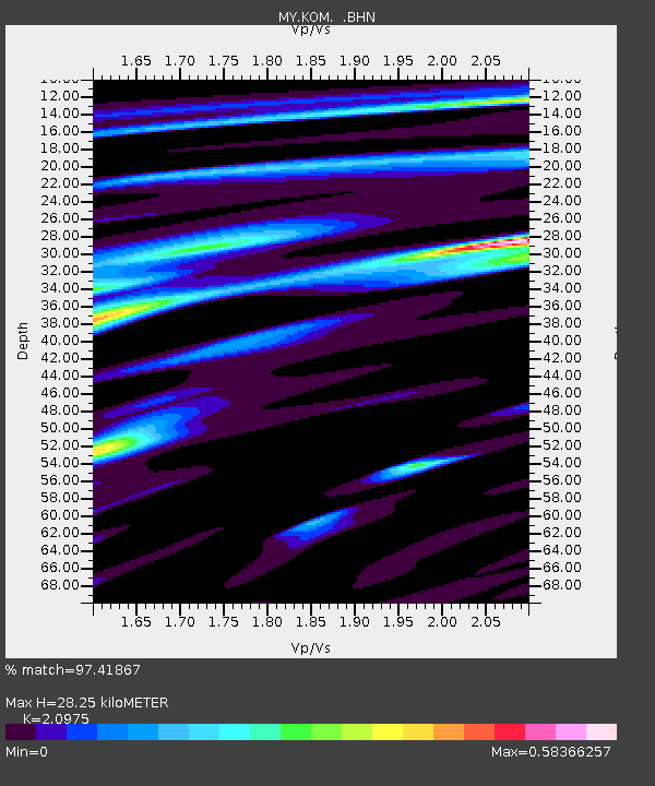
KOM Kota Tinggi - Earthquake Result Viewer

Earthquake location: Loyalty Islands
Earthquake latitude/longitude: -20.2/168.9
Earthquake time(UTC): 2008/04/09 (100) 11:13:17 GMT
Earthquake Depth: 13 km
Earthquake Magnitude: 5.6 MB, 6.3 MS, 6.4 MW, 6.3 MW
Earthquake Catalog/Contributor: WHDF/NEIC
Network: MY Malaysian National Seismic Network
Station: KOM Kota Tinggi
Lat/Lon: 1.79 N/103.85 E
Elevation: 49 m
Distance: 67.3 deg
Az: 280.868 deg
Baz: 112.633 deg
Ray Param: 0.057041906
Estimated Moho Depth: 28.25 km
Estimated Crust Vp/Vs: 2.10
Assumed Crust Vp: 6.24 km/s
Estimated Crust Vs: 2.975 km/s
Estimated Crust Poisson's Ratio: 0.35
Radial Match: 97.41867 %
Radial Bump: 396
Transverse Match: 80.29199 %
Transverse Bump: 400
SOD ConfigId: 2504
Insert Time: 2010-03-09 03:31:21.008 +0000
GWidth: 2.5
Max Bumps: 400
Tol: 0.001

Signal To Noise

ChannelStoNSTALTA
MY:KOM: :BHN:20080409T11:23:40.320024Z2.20759531.7608686E-77.97641E-8
MY:KOM: :BHE:20080409T11:23:40.320024Z0.99223757.475251E-87.533732E-8
MY:KOM: :BHZ:20080409T11:23:40.320024Z1.92530181.2104056E-76.286835E-8
Arrivals
Ps5.1 SECOND
PpPs14 SECOND
PsPs/PpSs19 SECOND