You are here: Home > Network List > TA - USArray Transportable Network (new EarthScope stations) Stations List
> Station L15K Ungalak Mountain, AK, USA > Earthquake Result Viewer
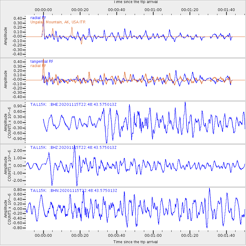
L15K Ungalak Mountain, AK, USA - Earthquake Result Viewer
*The percent match for this event was below the threshold and hence no stack was calculated.
| Earthquake location: |
Mindanao, Philippines |
| Earthquake latitude/longitude: |
8.7/126.3 |
| Earthquake time(UTC): |
2020/11/15 (320) 22:37:45 GMT |
| Earthquake Depth: |
59 km |
| Earthquake Magnitude: |
5.9 mww |
| Earthquake Catalog/Contributor: |
NEIC PDE/us |
|
| Network: |
TA USArray Transportable Network (new EarthScope stations) |
| Station: |
L15K Ungalak Mountain, AK, USA |
| Lat/Lon: |
61.68 N/161.49 W |
| Elevation: |
219 m |
|
| Distance: |
74.0 deg |
| Az: |
28.199 deg |
| Baz: |
258.39 deg |
| Ray Param: |
$rayparam |
*The percent match for this event was below the threshold and hence was not used in the summary stack. |
|
| Radial Match: |
74.31927 % |
| Radial Bump: |
400 |
| Transverse Match: |
58.625977 % |
| Transverse Bump: |
400 |
| SOD ConfigId: |
23341671 |
| Insert Time: |
2020-11-29 23:51:31.690 +0000 |
| GWidth: |
2.5 |
| Max Bumps: |
400 |
| Tol: |
0.001 |
|
Signal To Noise
| Channel | StoN | STA | LTA |
| TA:L15K: :BHZ:20201115T22:48:43.575013Z | 3.3924735 | 1.0429596E-6 | 3.074334E-7 |
| TA:L15K: :BHN:20201115T22:48:43.575013Z | 0.9386266 | 2.4989757E-7 | 2.6623746E-7 |
| TA:L15K: :BHE:20201115T22:48:43.575013Z | 2.181638 | 5.143998E-7 | 2.3578605E-7 |
| Arrivals |
| Ps | |
| PpPs | |
| PsPs/PpSs | |


