You are here: Home > Network List > G - GEOSCOPE Stations List
> Station MBO M'Bour, Senegal > Earthquake Result Viewer
MBO M'Bour, Senegal - Earthquake Result Viewer
| Earthquake location: |
Central Mexico |
| Earthquake latitude/longitude: |
18.6/-98.5 |
| Earthquake time(UTC): |
2017/09/19 (262) 18:14:38 GMT |
| Earthquake Depth: |
51 km |
| Earthquake Magnitude: |
7.1 Mww |
| Earthquake Catalog/Contributor: |
NEIC PDE/us |
|
| Network: |
G GEOSCOPE |
| Station: |
MBO M'Bour, Senegal |
| Lat/Lon: |
14.39 N/16.95 W |
| Elevation: |
3.0 m |
|
| Distance: |
77.7 deg |
| Az: |
78.833 deg |
| Baz: |
286.166 deg |
| Ray Param: |
0.050062772 |
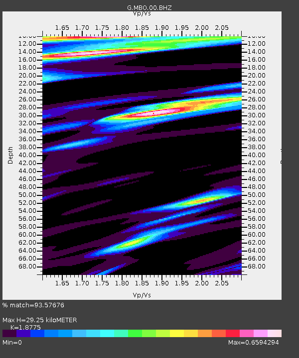
| Estimated Moho Depth: |
29.25 km |
| Estimated Crust Vp/Vs: |
1.88 |
| Assumed Crust Vp: |
5.55 km/s |
| Estimated Crust Vs: |
2.956 km/s |
| Estimated Crust Poisson's Ratio: |
0.30 |
|
| Radial Match: |
93.57676 % |
| Radial Bump: |
365 |
| Transverse Match: |
88.914795 % |
| Transverse Bump: |
308 |
| SOD ConfigId: |
2341311 |
| Insert Time: |
2017-10-03 18:31:35.532 +0000 |
| GWidth: |
2.5 |
| Max Bumps: |
400 |
| Tol: |
0.001 |
|

Signal To Noise
| Channel | StoN | STA | LTA |
| G:MBO:00:BHZ:20170919T18:25:58.64998Z | 8.166745 | 9.472467E-6 | 1.1598828E-6 |
| G:MBO:00:BHN:20170919T18:25:58.64998Z | 1.0742972 | 1.1036735E-6 | 1.0273448E-6 |
| G:MBO:00:BHE:20170919T18:25:58.64998Z | 2.2983186 | 1.8217369E-6 | 7.926389E-7 |
| Arrivals |
| Ps | 4.7 SECOND |
| PpPs | 15 SECOND |
| PsPs/PpSs | 20 SECOND |


