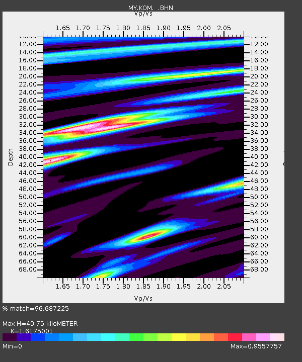
KOM Kota Tinggi - Earthquake Result Viewer

Earthquake location: Tajikistan-Xinjiang Border Reg.
Earthquake latitude/longitude: 39.5/73.8
Earthquake time(UTC): 2008/10/05 (279) 15:52:49 GMT
Earthquake Depth: 27 km
Earthquake Magnitude: 6.4 MB, 6.9 MS, 6.6 MW, 6.6 MW
Earthquake Catalog/Contributor: WHDF/NEIC
Network: MY Malaysian National Seismic Network
Station: KOM Kota Tinggi
Lat/Lon: 1.79 N/103.85 E
Elevation: 49 m
Distance: 46.5 deg
Az: 136.371 deg
Baz: 327.733 deg
Ray Param: 0.07058886
Estimated Moho Depth: 40.75 km
Estimated Crust Vp/Vs: 1.62
Assumed Crust Vp: 6.24 km/s
Estimated Crust Vs: 3.858 km/s
Estimated Crust Poisson's Ratio: 0.19
Radial Match: 96.687225 %
Radial Bump: 282
Transverse Match: 81.78843 %
Transverse Bump: 400
SOD ConfigId: 2556
Insert Time: 2010-03-09 03:32:07.931 +0000
GWidth: 2.5
Max Bumps: 400
Tol: 0.001

Signal To Noise

ChannelStoNSTALTA
MY:KOM: :BHN:20081005T16:00:43.120001Z14.0874985.8368437E-74.143279E-8
MY:KOM: :BHE:20081005T16:00:43.120001Z5.02417143.1469256E-76.263571E-8
MY:KOM: :BHZ:20081005T16:00:43.120001Z2.08857682.4068586E-71.15239175E-7
Arrivals
Ps4.3 SECOND
PpPs16 SECOND
PsPs/PpSs20 SECOND