You are here: Home > Network List > GO - National Seismic Network of Georgia Stations List
> Station TBLG Delisi, Georgia > Earthquake Result Viewer
TBLG Delisi, Georgia - Earthquake Result Viewer
| Earthquake location: |
Southern Sumatra, Indonesia |
| Earthquake latitude/longitude: |
-2.7/99.3 |
| Earthquake time(UTC): |
2020/11/17 (322) 01:44:09 GMT |
| Earthquake Depth: |
10 km |
| Earthquake Magnitude: |
5.8 Mww |
| Earthquake Catalog/Contributor: |
NEIC PDE/us |
|
| Network: |
GO National Seismic Network of Georgia |
| Station: |
TBLG Delisi, Georgia |
| Lat/Lon: |
41.73 N/44.74 E |
| Elevation: |
510 m |
|
| Distance: |
66.3 deg |
| Az: |
318.226 deg |
| Baz: |
117.242 deg |
| Ray Param: |
0.057728805 |
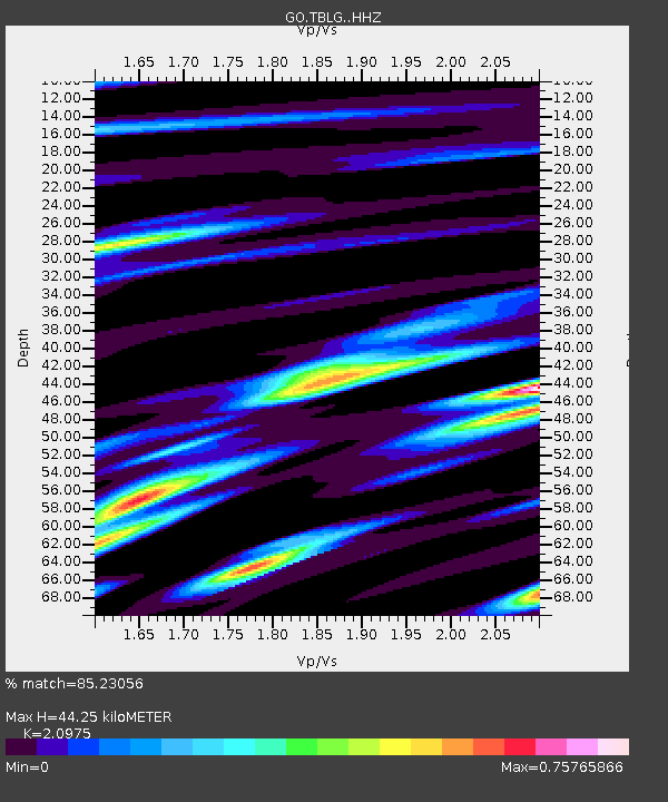
| Estimated Moho Depth: |
44.25 km |
| Estimated Crust Vp/Vs: |
2.10 |
| Assumed Crust Vp: |
6.291 km/s |
| Estimated Crust Vs: |
2.999 km/s |
| Estimated Crust Poisson's Ratio: |
0.35 |
|
| Radial Match: |
85.23056 % |
| Radial Bump: |
383 |
| Transverse Match: |
68.251816 % |
| Transverse Bump: |
400 |
| SOD ConfigId: |
23341671 |
| Insert Time: |
2020-12-01 02:47:35.117 +0000 |
| GWidth: |
2.5 |
| Max Bumps: |
400 |
| Tol: |
0.001 |
|
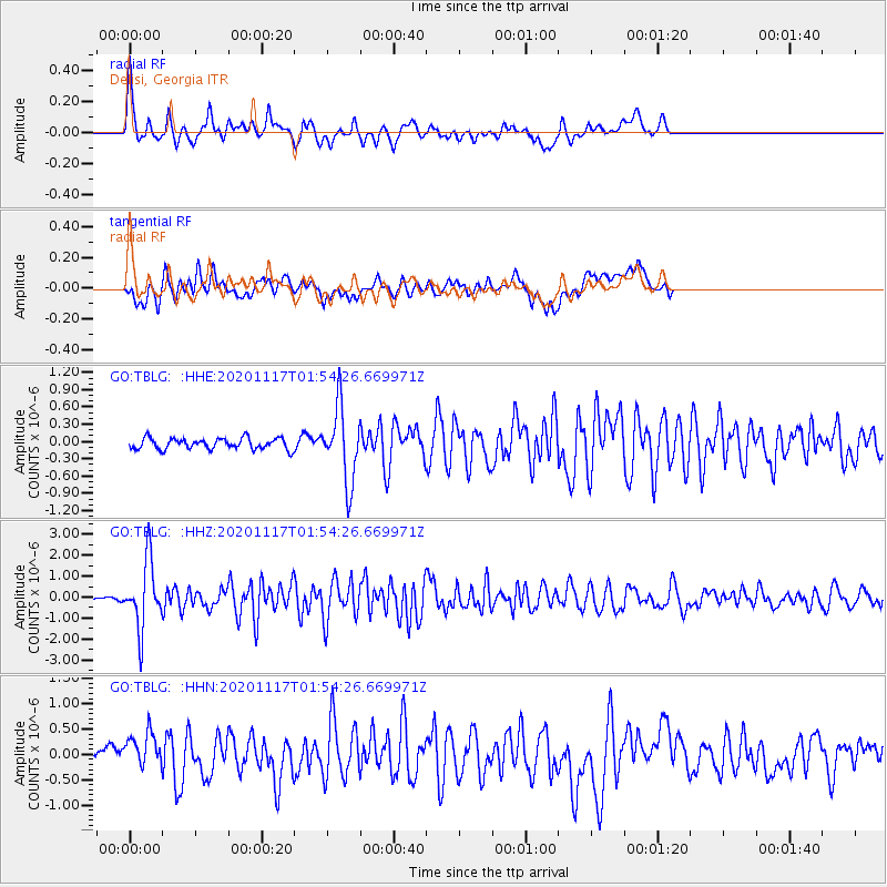
Signal To Noise
| Channel | StoN | STA | LTA |
| GO:TBLG: :HHZ:20201117T01:54:26.669971Z | 15.177507 | 1.5816673E-6 | 1.04211274E-7 |
| GO:TBLG: :HHN:20201117T01:54:26.669971Z | 2.5444775 | 3.5672198E-7 | 1.401946E-7 |
| GO:TBLG: :HHE:20201117T01:54:26.669971Z | 6.7242756 | 6.382433E-7 | 9.4916295E-8 |
| Arrivals |
| Ps | 8.0 SECOND |
| PpPs | 21 SECOND |
| PsPs/PpSs | 29 SECOND |


