You are here: Home > Network List > GS - US Geological Survey Networks Stations List
> Station MT02 Nevada Ogden Rd, Helena Natl Forest, Montana, USA > Earthquake Result Viewer
MT02 Nevada Ogden Rd, Helena Natl Forest, Montana, USA - Earthquake Result Viewer
| Earthquake location: |
Central Mexico |
| Earthquake latitude/longitude: |
18.6/-98.5 |
| Earthquake time(UTC): |
2017/09/19 (262) 18:14:38 GMT |
| Earthquake Depth: |
51 km |
| Earthquake Magnitude: |
7.1 Mww |
| Earthquake Catalog/Contributor: |
NEIC PDE/us |
|
| Network: |
GS US Geological Survey Networks |
| Station: |
MT02 Nevada Ogden Rd, Helena Natl Forest, Montana, USA |
| Lat/Lon: |
46.86 N/112.88 W |
| Elevation: |
1672 m |
|
| Distance: |
30.6 deg |
| Az: |
340.438 deg |
| Baz: |
152.427 deg |
| Ray Param: |
0.07922142 |
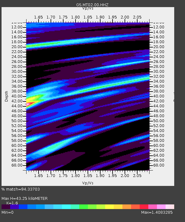
| Estimated Moho Depth: |
43.25 km |
| Estimated Crust Vp/Vs: |
1.60 |
| Assumed Crust Vp: |
6.353 km/s |
| Estimated Crust Vs: |
3.971 km/s |
| Estimated Crust Poisson's Ratio: |
0.18 |
|
| Radial Match: |
94.33703 % |
| Radial Bump: |
325 |
| Transverse Match: |
75.2347 % |
| Transverse Bump: |
400 |
| SOD ConfigId: |
2341311 |
| Insert Time: |
2017-10-03 18:32:36.565 +0000 |
| GWidth: |
2.5 |
| Max Bumps: |
400 |
| Tol: |
0.001 |
|

Signal To Noise
| Channel | StoN | STA | LTA |
| GS:MT02:00:HHZ:20170919T18:20:17.393999Z | 19.388876 | 4.194909E-6 | 2.1635647E-7 |
| GS:MT02:00:HH1:20170919T18:20:17.393999Z | 11.032326 | 2.260109E-6 | 2.0486245E-7 |
| GS:MT02:00:HH2:20170919T18:20:17.393999Z | 3.6822119 | 1.0407055E-6 | 2.8263054E-7 |
| Arrivals |
| Ps | 4.5 SECOND |
| PpPs | 16 SECOND |
| PsPs/PpSs | 21 SECOND |


