You are here: Home > Network List > IU - Global Seismograph Network (GSN - IRIS/USGS) Stations List
> Station JOHN Johnston Island, USA > Earthquake Result Viewer
JOHN Johnston Island, USA - Earthquake Result Viewer
| Earthquake location: |
Central Mexico |
| Earthquake latitude/longitude: |
18.6/-98.5 |
| Earthquake time(UTC): |
2017/09/19 (262) 18:14:38 GMT |
| Earthquake Depth: |
51 km |
| Earthquake Magnitude: |
7.1 Mww |
| Earthquake Catalog/Contributor: |
NEIC PDE/us |
|
| Network: |
IU Global Seismograph Network (GSN - IRIS/USGS) |
| Station: |
JOHN Johnston Island, USA |
| Lat/Lon: |
16.73 N/169.53 W |
| Elevation: |
2.0 m |
|
| Distance: |
67.3 deg |
| Az: |
280.806 deg |
| Baz: |
76.534 deg |
| Ray Param: |
0.056942403 |
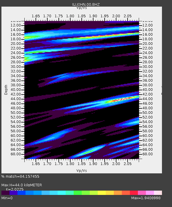
| Estimated Moho Depth: |
44.0 km |
| Estimated Crust Vp/Vs: |
2.02 |
| Assumed Crust Vp: |
4.24 km/s |
| Estimated Crust Vs: |
2.096 km/s |
| Estimated Crust Poisson's Ratio: |
0.34 |
|
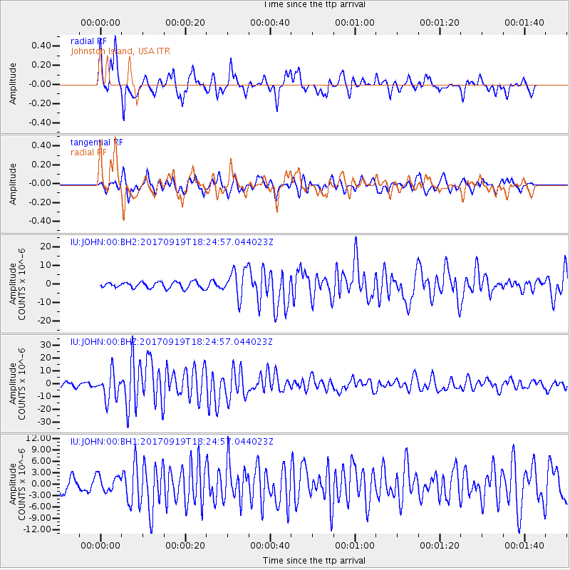
| Radial Match: |
84.157455 % |
| Radial Bump: |
400 |
| Transverse Match: |
71.64573 % |
| Transverse Bump: |
400 |
| SOD ConfigId: |
2341311 |
| Insert Time: |
2017-10-03 18:33:43.612 +0000 |
| GWidth: |
2.5 |
| Max Bumps: |
400 |
| Tol: |
0.001 |
|
Signal To Noise
| Channel | StoN | STA | LTA |
| IU:JOHN:00:BHZ:20170919T18:24:57.044023Z | 7.768608 | 1.0483459E-5 | 1.3494642E-6 |
| IU:JOHN:00:BH1:20170919T18:24:57.044023Z | 1.5657873 | 2.0697248E-6 | 1.3218429E-6 |
| IU:JOHN:00:BH2:20170919T18:24:57.044023Z | 4.7564993 | 7.807361E-6 | 1.641409E-6 |
| Arrivals |
| Ps | 11 SECOND |
| PpPs | 31 SECOND |
| PsPs/PpSs | 42 SECOND |


