You are here: Home > Network List > IU - Global Seismograph Network (GSN - IRIS/USGS) Stations List
> Station POHA Pohakuloa, Hawaii, USA > Earthquake Result Viewer
POHA Pohakuloa, Hawaii, USA - Earthquake Result Viewer
| Earthquake location: |
Central Mexico |
| Earthquake latitude/longitude: |
18.6/-98.5 |
| Earthquake time(UTC): |
2017/09/19 (262) 18:14:38 GMT |
| Earthquake Depth: |
51 km |
| Earthquake Magnitude: |
7.1 Mww |
| Earthquake Catalog/Contributor: |
NEIC PDE/us |
|
| Network: |
IU Global Seismograph Network (GSN - IRIS/USGS) |
| Station: |
POHA Pohakuloa, Hawaii, USA |
| Lat/Lon: |
19.76 N/155.53 W |
| Elevation: |
1990 m |
|
| Distance: |
53.7 deg |
| Az: |
281.216 deg |
| Baz: |
81.114 deg |
| Ray Param: |
0.06581462 |
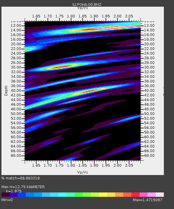
| Estimated Moho Depth: |
12.75 km |
| Estimated Crust Vp/Vs: |
1.98 |
| Assumed Crust Vp: |
5.195 km/s |
| Estimated Crust Vs: |
2.63 km/s |
| Estimated Crust Poisson's Ratio: |
0.33 |
|
| Radial Match: |
86.663216 % |
| Radial Bump: |
387 |
| Transverse Match: |
85.35471 % |
| Transverse Bump: |
400 |
| SOD ConfigId: |
2341311 |
| Insert Time: |
2017-10-03 18:34:09.972 +0000 |
| GWidth: |
2.5 |
| Max Bumps: |
400 |
| Tol: |
0.001 |
|
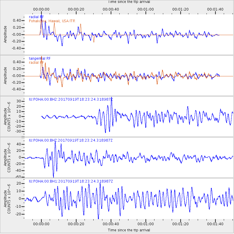
Signal To Noise
| Channel | StoN | STA | LTA |
| IU:POHA:00:BHZ:20170919T18:23:24.318987Z | 12.559225 | 1.4950864E-5 | 1.190429E-6 |
| IU:POHA:00:BH1:20170919T18:23:24.318987Z | 3.1442993 | 4.721924E-6 | 1.5017414E-6 |
| IU:POHA:00:BH2:20170919T18:23:24.318987Z | 5.527298 | 8.490394E-6 | 1.5360841E-6 |
| Arrivals |
| Ps | 2.5 SECOND |
| PpPs | 7.1 SECOND |
| PsPs/PpSs | 9.5 SECOND |


