You are here: Home > Network List > IU - Global Seismograph Network (GSN - IRIS/USGS) Stations List
> Station RAR Rarotonga, Cook Islands > Earthquake Result Viewer
RAR Rarotonga, Cook Islands - Earthquake Result Viewer

| Earthquake location: |
Central Mexico |
| Earthquake latitude/longitude: |
18.6/-98.5 |
| Earthquake time(UTC): |
2017/09/19 (262) 18:14:38 GMT |
| Earthquake Depth: |
51 km |
| Earthquake Magnitude: |
7.1 Mww |
| Earthquake Catalog/Contributor: |
NEIC PDE/us |
|
| Network: |
IU Global Seismograph Network (GSN - IRIS/USGS) |
| Station: |
RAR Rarotonga, Cook Islands |
| Lat/Lon: |
21.21 S/159.77 W |
| Elevation: |
28 m |
|
| Distance: |
71.8 deg |
| Az: |
239.444 deg |
| Baz: |
61.108 deg |
| Ray Param: |
0.053955697 |
| Estimated Moho Depth: |
58.5 km |
| Estimated Crust Vp/Vs: |
1.78 |
| Assumed Crust Vp: |
4.24 km/s |
| Estimated Crust Vs: |
2.379 km/s |
| Estimated Crust Poisson's Ratio: |
0.27 |
|
| Radial Match: |
82.94168 % |
| Radial Bump: |
322 |
| Transverse Match: |
50.48667 % |
| Transverse Bump: |
400 |
| SOD ConfigId: |
2341311 |
| Insert Time: |
2017-10-03 18:34:12.289 +0000 |
| GWidth: |
2.5 |
| Max Bumps: |
400 |
| Tol: |
0.001 |
|
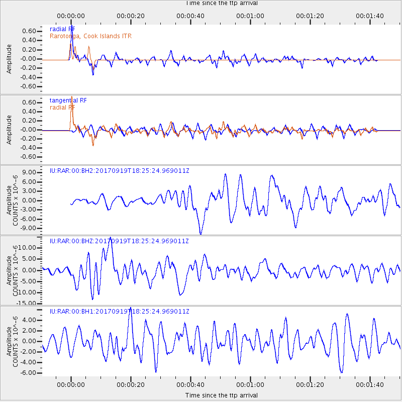
Signal To Noise
| Channel | StoN | STA | LTA |
| IU:RAR:00:BHZ:20170919T18:25:24.969011Z | 2.9455347 | 4.0827767E-6 | 1.3860903E-6 |
| IU:RAR:00:BH1:20170919T18:25:24.969011Z | 1.5640581 | 1.8654026E-6 | 1.1926684E-6 |
| IU:RAR:00:BH2:20170919T18:25:24.969011Z | 1.8200326 | 1.9688255E-6 | 1.0817529E-6 |
| Arrivals |
| Ps | 11 SECOND |
| PpPs | 38 SECOND |
| PsPs/PpSs | 49 SECOND |


