You are here: Home > Network List > IU - Global Seismograph Network (GSN - IRIS/USGS) Stations List
> Station SFJD Sondre Stromfjord, Greenland > Earthquake Result Viewer
SFJD Sondre Stromfjord, Greenland - Earthquake Result Viewer
| Earthquake location: |
Central Mexico |
| Earthquake latitude/longitude: |
18.6/-98.5 |
| Earthquake time(UTC): |
2017/09/19 (262) 18:14:38 GMT |
| Earthquake Depth: |
51 km |
| Earthquake Magnitude: |
7.1 Mww |
| Earthquake Catalog/Contributor: |
NEIC PDE/us |
|
| Network: |
IU Global Seismograph Network (GSN - IRIS/USGS) |
| Station: |
SFJD Sondre Stromfjord, Greenland |
| Lat/Lon: |
67.00 N/50.62 W |
| Elevation: |
330 m |
|
| Distance: |
57.3 deg |
| Az: |
20.278 deg |
| Baz: |
236.778 deg |
| Ray Param: |
0.06349063 |
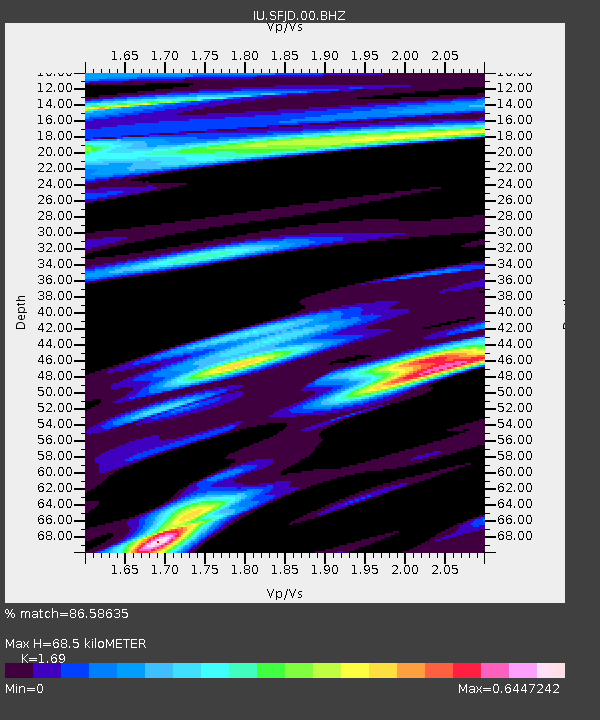
| Estimated Moho Depth: |
68.5 km |
| Estimated Crust Vp/Vs: |
1.69 |
| Assumed Crust Vp: |
6.459 km/s |
| Estimated Crust Vs: |
3.822 km/s |
| Estimated Crust Poisson's Ratio: |
0.23 |
|
| Radial Match: |
86.58635 % |
| Radial Bump: |
400 |
| Transverse Match: |
71.54477 % |
| Transverse Bump: |
400 |
| SOD ConfigId: |
2341311 |
| Insert Time: |
2017-10-03 18:34:21.375 +0000 |
| GWidth: |
2.5 |
| Max Bumps: |
400 |
| Tol: |
0.001 |
|
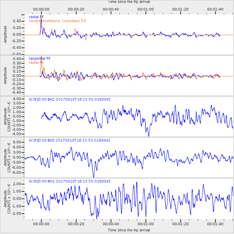
Signal To Noise
| Channel | StoN | STA | LTA |
| IU:SFJD:00:BHZ:20170919T18:23:50.018999Z | 6.5588474 | 3.3749407E-6 | 5.1456306E-7 |
| IU:SFJD:00:BH1:20170919T18:23:50.018999Z | 3.4664128 | 9.982065E-7 | 2.8796526E-7 |
| IU:SFJD:00:BH2:20170919T18:23:50.018999Z | 3.1945794 | 1.555332E-6 | 4.86866E-7 |
| Arrivals |
| Ps | 7.7 SECOND |
| PpPs | 27 SECOND |
| PsPs/PpSs | 35 SECOND |


