You are here: Home > Network List > US - United States National Seismic Network Stations List
> Station WUAZ Wupatki, Arizona, USA > Earthquake Result Viewer
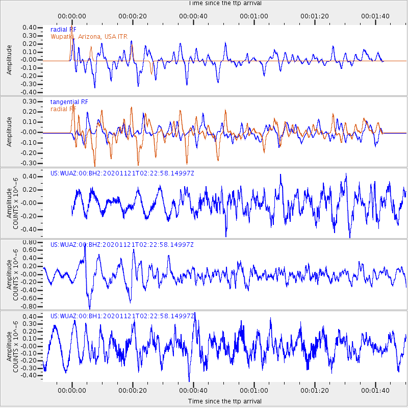
WUAZ Wupatki, Arizona, USA - Earthquake Result Viewer
*The percent match for this event was below the threshold and hence no stack was calculated.
| Earthquake location: |
Near Coast Of Central Chile |
| Earthquake latitude/longitude: |
-30.9/-71.5 |
| Earthquake time(UTC): |
2020/11/21 (326) 02:11:47 GMT |
| Earthquake Depth: |
54 km |
| Earthquake Magnitude: |
5.6 Mww |
| Earthquake Catalog/Contributor: |
NEIC PDE/us |
|
| Network: |
US United States National Seismic Network |
| Station: |
WUAZ Wupatki, Arizona, USA |
| Lat/Lon: |
35.52 N/111.37 W |
| Elevation: |
1592 m |
|
| Distance: |
76.0 deg |
| Az: |
327.381 deg |
| Baz: |
145.39 deg |
| Ray Param: |
$rayparam |
*The percent match for this event was below the threshold and hence was not used in the summary stack. |
|
| Radial Match: |
53.08726 % |
| Radial Bump: |
400 |
| Transverse Match: |
64.25828 % |
| Transverse Bump: |
400 |
| SOD ConfigId: |
23341671 |
| Insert Time: |
2020-12-05 03:29:39.180 +0000 |
| GWidth: |
2.5 |
| Max Bumps: |
400 |
| Tol: |
0.001 |
|
Signal To Noise
| Channel | StoN | STA | LTA |
| US:WUAZ:00:BHZ:20201121T02:22:58.14997Z | 2.7272732 | 2.95337E-7 | 1.0829021E-7 |
| US:WUAZ:00:BH1:20201121T02:22:58.14997Z | 1.3257172 | 1.9872863E-7 | 1.4990273E-7 |
| US:WUAZ:00:BH2:20201121T02:22:58.14997Z | 1.345075 | 1.5297529E-7 | 1.1372993E-7 |
| Arrivals |
| Ps | |
| PpPs | |
| PsPs/PpSs | |


