You are here: Home > Network List > US - United States National Seismic Network Stations List
> Station LBNH Lisbon, New Hampshire, USA > Earthquake Result Viewer
LBNH Lisbon, New Hampshire, USA - Earthquake Result Viewer

| Earthquake location: |
Central Mexico |
| Earthquake latitude/longitude: |
18.6/-98.5 |
| Earthquake time(UTC): |
2017/09/19 (262) 18:14:38 GMT |
| Earthquake Depth: |
51 km |
| Earthquake Magnitude: |
7.1 Mww |
| Earthquake Catalog/Contributor: |
NEIC PDE/us |
|
| Network: |
US United States National Seismic Network |
| Station: |
LBNH Lisbon, New Hampshire, USA |
| Lat/Lon: |
44.24 N/71.93 W |
| Elevation: |
367 m |
|
| Distance: |
33.9 deg |
| Az: |
35.17 deg |
| Baz: |
229.486 deg |
| Ray Param: |
0.077870384 |
| Estimated Moho Depth: |
30.5 km |
| Estimated Crust Vp/Vs: |
1.99 |
| Assumed Crust Vp: |
6.419 km/s |
| Estimated Crust Vs: |
3.222 km/s |
| Estimated Crust Poisson's Ratio: |
0.33 |
|
| Radial Match: |
92.183044 % |
| Radial Bump: |
290 |
| Transverse Match: |
60.57932 % |
| Transverse Bump: |
400 |
| SOD ConfigId: |
2341311 |
| Insert Time: |
2017-10-03 18:36:03.413 +0000 |
| GWidth: |
2.5 |
| Max Bumps: |
400 |
| Tol: |
0.001 |
|
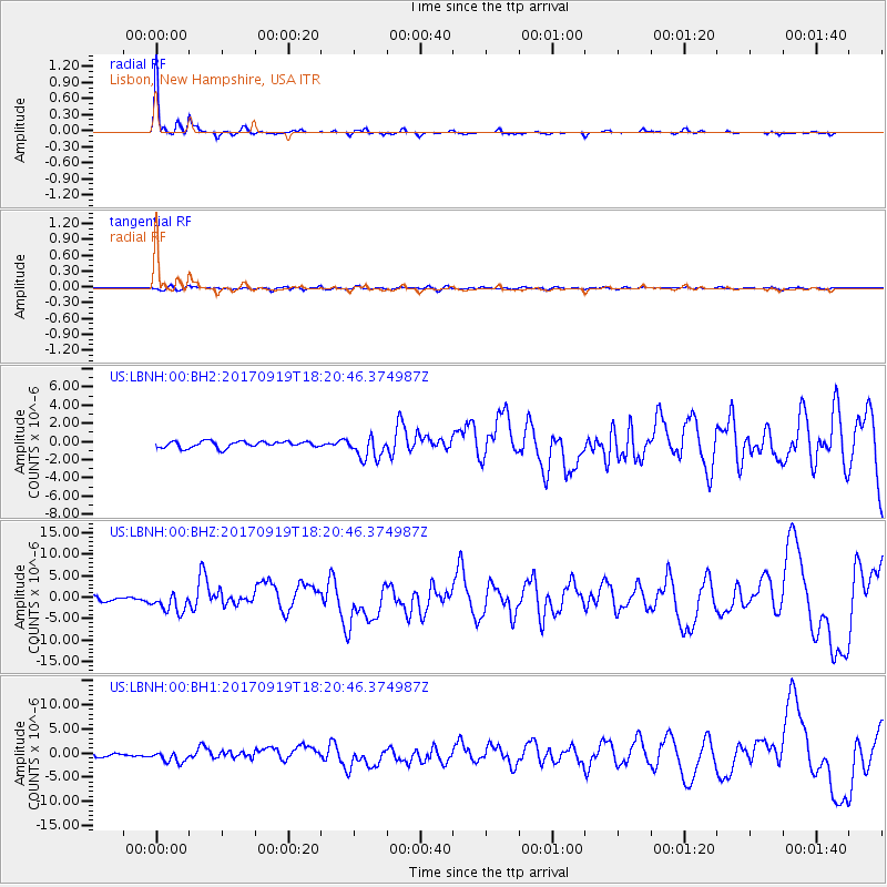
Signal To Noise
| Channel | StoN | STA | LTA |
| US:LBNH:00:BHZ:20170919T18:20:46.374987Z | 4.5064087 | 2.2634774E-6 | 5.0227965E-7 |
| US:LBNH:00:BH1:20170919T18:20:46.374987Z | 2.3291845 | 1.1207561E-6 | 4.811796E-7 |
| US:LBNH:00:BH2:20170919T18:20:46.374987Z | 3.5487885 | 1.2410623E-6 | 3.4971436E-7 |
| Arrivals |
| Ps | 5.0 SECOND |
| PpPs | 13 SECOND |
| PsPs/PpSs | 18 SECOND |


