You are here: Home > Network List > US - United States National Seismic Network Stations List
> Station PKME Peaks-Kenny State Park, Maine, USA > Earthquake Result Viewer
PKME Peaks-Kenny State Park, Maine, USA - Earthquake Result Viewer
| Earthquake location: |
Central Mexico |
| Earthquake latitude/longitude: |
18.6/-98.5 |
| Earthquake time(UTC): |
2017/09/19 (262) 18:14:38 GMT |
| Earthquake Depth: |
51 km |
| Earthquake Magnitude: |
7.1 Mww |
| Earthquake Catalog/Contributor: |
NEIC PDE/us |
|
| Network: |
US United States National Seismic Network |
| Station: |
PKME Peaks-Kenny State Park, Maine, USA |
| Lat/Lon: |
45.26 N/69.29 W |
| Elevation: |
108 m |
|
| Distance: |
36.0 deg |
| Az: |
35.862 deg |
| Baz: |
231.901 deg |
| Ray Param: |
0.07677423 |
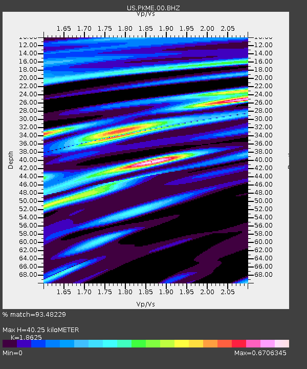
| Estimated Moho Depth: |
40.25 km |
| Estimated Crust Vp/Vs: |
1.86 |
| Assumed Crust Vp: |
6.419 km/s |
| Estimated Crust Vs: |
3.447 km/s |
| Estimated Crust Poisson's Ratio: |
0.30 |
|
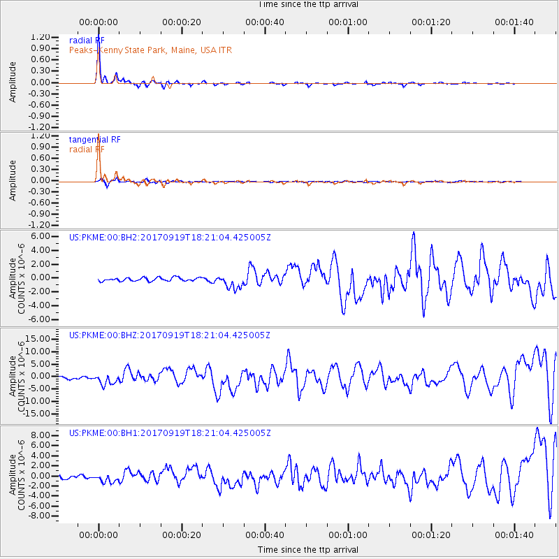
| Radial Match: |
93.48229 % |
| Radial Bump: |
177 |
| Transverse Match: |
70.11534 % |
| Transverse Bump: |
400 |
| SOD ConfigId: |
2341311 |
| Insert Time: |
2017-10-03 18:36:13.880 +0000 |
| GWidth: |
2.5 |
| Max Bumps: |
400 |
| Tol: |
0.001 |
|
Signal To Noise
| Channel | StoN | STA | LTA |
| US:PKME:00:BHZ:20170919T18:21:04.425005Z | 5.0465217 | 2.0809603E-6 | 4.1235538E-7 |
| US:PKME:00:BH1:20170919T18:21:04.425005Z | 2.5807319 | 8.321694E-7 | 3.2245484E-7 |
| US:PKME:00:BH2:20170919T18:21:04.425005Z | 4.1586947 | 1.0350282E-6 | 2.488829E-7 |
| Arrivals |
| Ps | 5.8 SECOND |
| PpPs | 17 SECOND |
| PsPs/PpSs | 23 SECOND |


