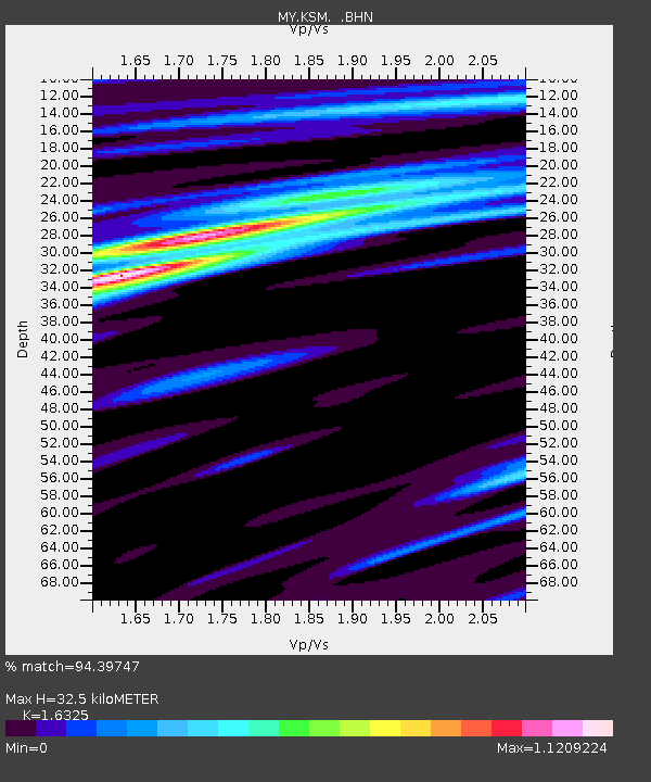
KSM Kuching - Earthquake Result Viewer

Earthquake location: New Britain Region, P.N.G.
Earthquake latitude/longitude: -6.6/152.2
Earthquake time(UTC): 2005/12/11 (345) 14:20:43 GMT
Earthquake Depth: 10 km
Earthquake Magnitude: 6.2 MB, 6.2 MS, 6.6 MW, 6.5 MW
Earthquake Catalog/Contributor: WHDF/NEIC
Network: MY Malaysian National Seismic Network
Station: KSM Kuching
Lat/Lon: 1.47 N/110.31 E
Elevation: 66 m
Distance: 42.6 deg
Az: 279.353 deg
Baz: 101.294 deg
Ray Param: 0.07310129
Estimated Moho Depth: 32.5 km
Estimated Crust Vp/Vs: 1.63
Assumed Crust Vp: 6.468 km/s
Estimated Crust Vs: 3.962 km/s
Estimated Crust Poisson's Ratio: 0.20
Radial Match: 94.39747 %
Radial Bump: 343
Transverse Match: 77.436554 %
Transverse Bump: 400
SOD ConfigId: 2564
Insert Time: 2010-03-09 03:35:02.068 +0000
GWidth: 2.5
Max Bumps: 400
Tol: 0.001

Signal To Noise

ChannelStoNSTALTA
MY:KSM: :BHN:20051211T14:28:08.818015Z3.926185.125258E-71.3054057E-7
MY:KSM: :BHE:20051211T14:28:08.818015Z11.9338941.335061E-61.11871366E-7
MY:KSM: :BHZ:20051211T14:28:08.818015Z24.4707583.3363378E-61.3633978E-7
Arrivals
Ps3.4 SECOND
PpPs12 SECOND
PsPs/PpSs16 SECOND