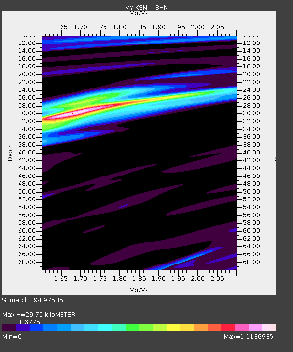
KSM Kuching - Earthquake Result Viewer

Earthquake location: Near East Coast Of Honshu, Japan
Earthquake latitude/longitude: 38.1/142.1
Earthquake time(UTC): 2005/12/02 (336) 13:13:09 GMT
Earthquake Depth: 29 km
Earthquake Magnitude: 6.1 MB, 6.3 MS, 6.5 MW, 6.4 MW
Earthquake Catalog/Contributor: WHDF/NEIC
Network: MY Malaysian National Seismic Network
Station: KSM Kuching
Lat/Lon: 1.47 N/110.31 E
Elevation: 66 m
Distance: 46.7 deg
Az: 226.408 deg
Baz: 34.867 deg
Ray Param: 0.07043534
Estimated Moho Depth: 29.75 km
Estimated Crust Vp/Vs: 1.68
Assumed Crust Vp: 6.468 km/s
Estimated Crust Vs: 3.856 km/s
Estimated Crust Poisson's Ratio: 0.22
Radial Match: 94.97585 %
Radial Bump: 357
Transverse Match: 85.197716 %
Transverse Bump: 400
SOD ConfigId: 2422
Insert Time: 2010-03-09 03:35:14.579 +0000
GWidth: 2.5
Max Bumps: 400
Tol: 0.001

Signal To Noise

ChannelStoNSTALTA
MY:KSM: :BHN:20051202T13:21:04.918987Z24.6749441.5210496E-66.164349E-8
MY:KSM: :BHE:20051202T13:21:04.918987Z21.5514491.2474559E-65.788269E-8
MY:KSM: :BHZ:20051202T13:21:04.918987Z49.839293.686832E-67.397441E-8
Arrivals
Ps3.3 SECOND
PpPs12 SECOND
PsPs/PpSs15 SECOND