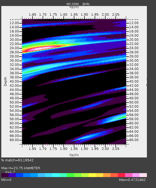
KSM Kuching - Earthquake Result Viewer

Earthquake location: Samoa Islands Region
Earthquake latitude/longitude: -16.7/-172.7
Earthquake time(UTC): 2005/09/22 (265) 00:07:21 GMT
Earthquake Depth: 10 km
Earthquake Magnitude: 5.3 MB, 5.7 MS, 5.9 MW, 5.8 MW
Earthquake Catalog/Contributor: WHDF/NEIC
Network: MY Malaysian National Seismic Network
Station: KSM Kuching
Lat/Lon: 1.47 N/110.31 E
Elevation: 66 m
Distance: 78.0 deg
Az: 275.186 deg
Baz: 107.28 deg
Ray Param: 0.04992981
Estimated Moho Depth: 23.75 km
Estimated Crust Vp/Vs: 1.70
Assumed Crust Vp: 6.468 km/s
Estimated Crust Vs: 3.805 km/s
Estimated Crust Poisson's Ratio: 0.24
Radial Match: 93.19542 %
Radial Bump: 357
Transverse Match: 85.63773 %
Transverse Bump: 400
SOD ConfigId: 2500
Insert Time: 2010-03-09 03:35:41.719 +0000
GWidth: 2.5
Max Bumps: 400
Tol: 0.001

Signal To Noise

ChannelStoNSTALTA
MY:KSM: :BHN:20050922T00:18:48.519016Z1.33138141.1489965E-78.630107E-8
MY:KSM: :BHE:20050922T00:18:48.519016Z2.52828742.0717326E-78.194213E-8
MY:KSM: :BHZ:20050922T00:18:48.519016Z8.815475.5477045E-76.293146E-8
Arrivals
Ps2.7 SECOND
PpPs9.6 SECOND
PsPs/PpSs12 SECOND