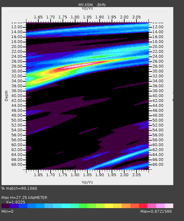
KSM Kuching - Earthquake Result Viewer

Earthquake location: Santa Cruz Islands
Earthquake latitude/longitude: -11.6/165.8
Earthquake time(UTC): 2007/09/02 (245) 01:05:18 GMT
Earthquake Depth: 35 km
Earthquake Magnitude: 5.9 MB, 7.3 MS, 7.2 MW, 6.9 ME
Earthquake Catalog/Contributor: WHDF/NEIC
Network: MY Malaysian National Seismic Network
Station: KSM Kuching
Lat/Lon: 1.47 N/110.31 E
Elevation: 66 m
Distance: 56.6 deg
Az: 279.54 deg
Baz: 104.857 deg
Ray Param: 0.063964926
Estimated Moho Depth: 27.25 km
Estimated Crust Vp/Vs: 1.82
Assumed Crust Vp: 6.468 km/s
Estimated Crust Vs: 3.549 km/s
Estimated Crust Poisson's Ratio: 0.28
Radial Match: 98.1868 %
Radial Bump: 330
Transverse Match: 89.645905 %
Transverse Bump: 400
SOD ConfigId: 2564
Insert Time: 2010-03-09 03:36:23.156 +0000
GWidth: 2.5
Max Bumps: 400
Tol: 0.001

Signal To Noise

ChannelStoNSTALTA
MY:KSM: :BHN:20070902T01:14:26.92002Z1.71012621.0886747E-76.366049E-8
MY:KSM: :BHE:20070902T01:14:26.92002Z3.24509022.8506378E-78.784464E-8
MY:KSM: :BHZ:20070902T01:14:26.92002Z6.11315358.172609E-71.3368893E-7
Arrivals
Ps3.6 SECOND
PpPs11 SECOND
PsPs/PpSs15 SECOND