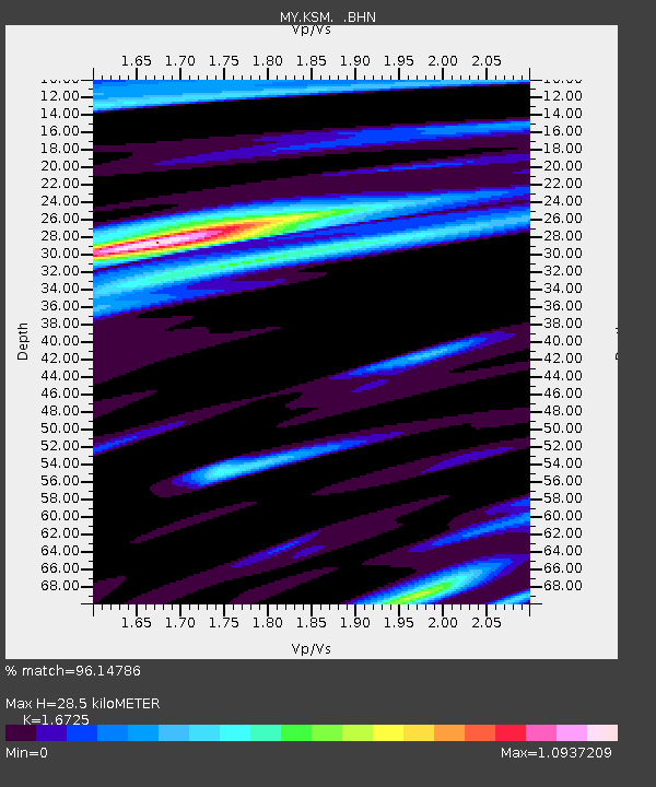
KSM Kuching - Earthquake Result Viewer

Earthquake location: Near West Coast Of Honshu, Japan
Earthquake latitude/longitude: 37.5/138.4
Earthquake time(UTC): 2007/07/16 (197) 01:13:22 GMT
Earthquake Depth: 12 km
Earthquake Magnitude: 6.5 MB, 6.4 MS, 6.6 MW, 6.5 MW
Earthquake Catalog/Contributor: WHDF/NEIC
Network: MY Malaysian National Seismic Network
Station: KSM Kuching
Lat/Lon: 1.47 N/110.31 E
Elevation: 66 m
Distance: 44.3 deg
Az: 222.499 deg
Baz: 32.495 deg
Ray Param: 0.07202542
Estimated Moho Depth: 28.5 km
Estimated Crust Vp/Vs: 1.67
Assumed Crust Vp: 6.468 km/s
Estimated Crust Vs: 3.867 km/s
Estimated Crust Poisson's Ratio: 0.22
Radial Match: 96.14786 %
Radial Bump: 393
Transverse Match: 85.00279 %
Transverse Bump: 400
SOD ConfigId: 2564
Insert Time: 2010-03-09 03:36:44.999 +0000
GWidth: 2.5
Max Bumps: 400
Tol: 0.001

Signal To Noise

ChannelStoNSTALTA
MY:KSM: :BHN:20070716T01:21:00.669011Z13.7375111.0978862E-67.9918856E-8
MY:KSM: :BHE:20070716T01:21:00.669011Z10.828858.419885E-77.7754194E-8
MY:KSM: :BHZ:20070716T01:21:00.669011Z25.5690172.6075693E-61.01981605E-7
Arrivals
Ps3.2 SECOND
PpPs11 SECOND
PsPs/PpSs14 SECOND