You are here: Home > Network List > IU - Global Seismograph Network (GSN - IRIS/USGS) Stations List
> Station RSSD Black Hills, South Dakota, USA > Earthquake Result Viewer
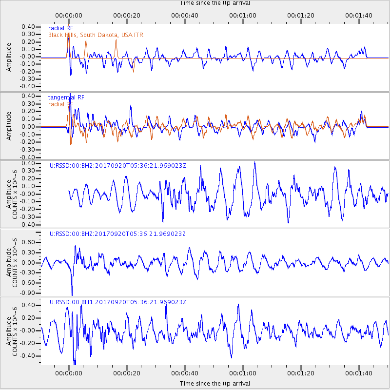
RSSD Black Hills, South Dakota, USA - Earthquake Result Viewer
*The percent match for this event was below the threshold and hence no stack was calculated.
| Earthquake location: |
Southern Peru |
| Earthquake latitude/longitude: |
-16.3/-71.3 |
| Earthquake time(UTC): |
2017/09/20 (263) 05:26:08 GMT |
| Earthquake Depth: |
93 km |
| Earthquake Magnitude: |
5.3 Mww |
| Earthquake Catalog/Contributor: |
NEIC PDE/us |
|
| Network: |
IU Global Seismograph Network (GSN - IRIS/USGS) |
| Station: |
RSSD Black Hills, South Dakota, USA |
| Lat/Lon: |
44.12 N/104.04 W |
| Elevation: |
2090 m |
|
| Distance: |
67.1 deg |
| Az: |
335.006 deg |
| Baz: |
145.704 deg |
| Ray Param: |
$rayparam |
*The percent match for this event was below the threshold and hence was not used in the summary stack. |
|
| Radial Match: |
46.834152 % |
| Radial Bump: |
400 |
| Transverse Match: |
55.575787 % |
| Transverse Bump: |
400 |
| SOD ConfigId: |
2341311 |
| Insert Time: |
2017-10-04 13:02:26.346 +0000 |
| GWidth: |
2.5 |
| Max Bumps: |
400 |
| Tol: |
0.001 |
|
Signal To Noise
| Channel | StoN | STA | LTA |
| IU:RSSD:00:BHZ:20170920T05:36:21.969023Z | 3.6500647 | 3.1380324E-7 | 8.597196E-8 |
| IU:RSSD:00:BH1:20170920T05:36:21.969023Z | 2.648322 | 2.9089153E-7 | 1.0983994E-7 |
| IU:RSSD:00:BH2:20170920T05:36:21.969023Z | 1.0951226 | 1.2356068E-7 | 1.1282817E-7 |
| Arrivals |
| Ps | |
| PpPs | |
| PsPs/PpSs | |


